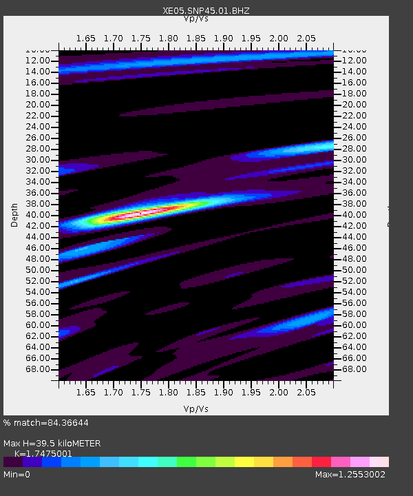
SNP45 SNP45 - Earthquake Result Viewer

Earthquake location: Southeast Of Loyalty Islands
Earthquake latitude/longitude: -22.7/169.5
Earthquake time(UTC): 2005/08/11 (223) 09:08:46 GMT
Earthquake Depth: 10 km
Earthquake Magnitude: 5.7 MB, 6.0 MS, 6.2 MW, 6.2 MW
Earthquake Catalog/Contributor: WHDF/NEIC
Network: XE Sierra Nevada EarthScope Project- EarthScope Flex Array
Station: SNP45 SNP45
Lat/Lon: 37.68 N/119.08 W
Elevation: 2571 m
Distance: 90.0 deg
Az: 48.763 deg
Baz: 241.094 deg
Ray Param: 0.04170578
Estimated Moho Depth: 39.5 km
Estimated Crust Vp/Vs: 1.75
Assumed Crust Vp: 6.291 km/s
Estimated Crust Vs: 3.6 km/s
Estimated Crust Poisson's Ratio: 0.26
Radial Match: 84.36644 %
Radial Bump: 400
Transverse Match: 70.723274 %
Transverse Bump: 400
SOD ConfigId: 268666
Insert Time: 2010-03-09 15:46:58.265 +0000
GWidth: 2.5
Max Bumps: 400
Tol: 0.001

Signal To Noise

ChannelStoNSTALTA
XE:SNP45:01:BHZ:20050811T09:21:14.760012Z3.3046581.8138311E-75.4887106E-8
XE:SNP45:01:BHN:20050811T09:21:14.760012Z1.59650036.6931236E-84.1923723E-8
XE:SNP45:01:BHE:20050811T09:21:14.760012Z1.53332175.9373026E-83.8721833E-8
Arrivals
Ps4.8 SECOND
PpPs17 SECOND
PsPs/PpSs22 SECOND