You are here: Home > Network List > XE05 - Sierra Nevada EarthScope Project- EarthScope Flex Array Stations List
> Station SNP45 SNP45 > Earthquake Result Viewer
SNP45 SNP45 - Earthquake Result Viewer
| Earthquake location: |
New Ireland Region, P.N.G. |
| Earthquake latitude/longitude: |
-4.5/153.5 |
| Earthquake time(UTC): |
2005/09/09 (252) 07:26:43 GMT |
| Earthquake Depth: |
90 km |
| Earthquake Magnitude: |
6.3 MB, 7.7 MW, 7.5 MW |
| Earthquake Catalog/Contributor: |
WHDF/NEIC |
|
| Network: |
XE Sierra Nevada EarthScope Project- EarthScope Flex Array |
| Station: |
SNP45 SNP45 |
| Lat/Lon: |
37.68 N/119.08 W |
| Elevation: |
2571 m |
|
| Distance: |
90.7 deg |
| Az: |
52.435 deg |
| Baz: |
264.868 deg |
| Ray Param: |
0.04163611 |
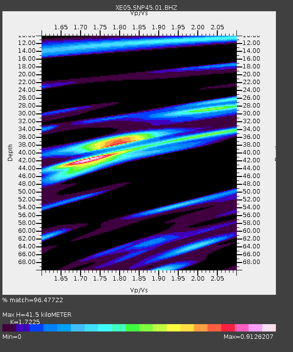
| Estimated Moho Depth: |
41.5 km |
| Estimated Crust Vp/Vs: |
1.72 |
| Assumed Crust Vp: |
6.291 km/s |
| Estimated Crust Vs: |
3.652 km/s |
| Estimated Crust Poisson's Ratio: |
0.25 |
|
| Radial Match: |
96.47722 % |
| Radial Bump: |
400 |
| Transverse Match: |
86.639465 % |
| Transverse Bump: |
400 |
| SOD ConfigId: |
268666 |
| Insert Time: |
2010-03-09 15:47:01.539 +0000 |
| GWidth: |
2.5 |
| Max Bumps: |
400 |
| Tol: |
0.001 |
|

Signal To Noise
| Channel | StoN | STA | LTA |
| XE:SNP45:01:BHZ:20050909T07:39:05.284016Z | 9.55357 | 9.448153E-7 | 9.889657E-8 |
| XE:SNP45:01:BHN:20050909T07:39:05.284016Z | 0.9453178 | 6.163323E-8 | 6.519842E-8 |
| XE:SNP45:01:BHE:20050909T07:39:05.284016Z | 3.836197 | 4.3011823E-7 | 1.12121E-7 |
| Arrivals |
| Ps | 4.9 SECOND |
| PpPs | 18 SECOND |
| PsPs/PpSs | 22 SECOND |


