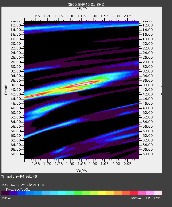
SNP45 SNP45 - Earthquake Result Viewer

Earthquake location: Fiji Islands Region
Earthquake latitude/longitude: -15.3/-178.6
Earthquake time(UTC): 2005/12/13 (347) 03:16:06 GMT
Earthquake Depth: 10 km
Earthquake Magnitude: 6.1 MB, 6.8 MS, 6.7 MW, 6.7 MW
Earthquake Catalog/Contributor: WHDF/NEIC
Network: XE Sierra Nevada EarthScope Project- EarthScope Flex Array
Station: SNP45 SNP45
Lat/Lon: 37.68 N/119.08 W
Elevation: 2571 m
Distance: 76.7 deg
Az: 44.61 deg
Baz: 238.685 deg
Ray Param: 0.05079722
Estimated Moho Depth: 37.25 km
Estimated Crust Vp/Vs: 1.86
Assumed Crust Vp: 6.291 km/s
Estimated Crust Vs: 3.387 km/s
Estimated Crust Poisson's Ratio: 0.30
Radial Match: 94.98176 %
Radial Bump: 348
Transverse Match: 83.309425 %
Transverse Bump: 400
SOD ConfigId: 268666
Insert Time: 2010-03-09 15:47:11.585 +0000
GWidth: 2.5
Max Bumps: 400
Tol: 0.001

Signal To Noise

ChannelStoNSTALTA
XE:SNP45:01:BHZ:20051213T03:27:26.395015Z6.46958889.895917E-71.5296054E-7
XE:SNP45:01:BHN:20051213T03:27:26.395015Z1.46728612.6827038E-71.8283441E-7
XE:SNP45:01:BHE:20051213T03:27:26.395015Z4.28535373.3555867E-77.8303614E-8
Arrivals
Ps5.2 SECOND
PpPs16 SECOND
PsPs/PpSs22 SECOND