You are here: Home > Network List > IU - Global Seismograph Network (GSN - IRIS/USGS) Stations List
> Station RSSD Black Hills, South Dakota, USA > Earthquake Result Viewer
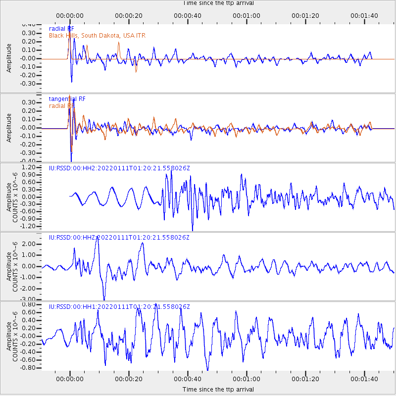
RSSD Black Hills, South Dakota, USA - Earthquake Result Viewer
*The percent match for this event was below the threshold and hence no stack was calculated.
| Earthquake location: |
Cyprus Region |
| Earthquake latitude/longitude: |
35.1/31.9 |
| Earthquake time(UTC): |
2022/01/11 (011) 01:07:47 GMT |
| Earthquake Depth: |
20 km |
| Earthquake Magnitude: |
6.6 Mww |
| Earthquake Catalog/Contributor: |
NEIC PDE/us |
|
| Network: |
IU Global Seismograph Network (GSN - IRIS/USGS) |
| Station: |
RSSD Black Hills, South Dakota, USA |
| Lat/Lon: |
44.12 N/104.04 W |
| Elevation: |
2090 m |
|
| Distance: |
91.5 deg |
| Az: |
329.936 deg |
| Baz: |
34.753 deg |
| Ray Param: |
$rayparam |
*The percent match for this event was below the threshold and hence was not used in the summary stack. |
|
| Radial Match: |
60.815357 % |
| Radial Bump: |
400 |
| Transverse Match: |
75.16242 % |
| Transverse Bump: |
400 |
| SOD ConfigId: |
26694651 |
| Insert Time: |
2022-01-25 01:21:22.321 +0000 |
| GWidth: |
2.5 |
| Max Bumps: |
400 |
| Tol: |
0.001 |
|
Signal To Noise
| Channel | StoN | STA | LTA |
| IU:RSSD:00:HHZ:20220111T01:20:21.558026Z | 4.044584 | 6.0012155E-7 | 1.4837657E-7 |
| IU:RSSD:00:HH1:20220111T01:20:21.558026Z | 1.2197025 | 2.1668781E-7 | 1.7765628E-7 |
| IU:RSSD:00:HH2:20220111T01:20:21.558026Z | 2.1947103 | 5.175648E-7 | 2.3582375E-7 |
| Arrivals |
| Ps | |
| PpPs | |
| PsPs/PpSs | |


