You are here: Home > Network List > N4 - Central and EAstern US Network Stations List
> Station SUSD Miller, SD, USA > Earthquake Result Viewer
SUSD Miller, SD, USA - Earthquake Result Viewer
| Earthquake location: |
Cyprus Region |
| Earthquake latitude/longitude: |
35.1/31.9 |
| Earthquake time(UTC): |
2022/01/11 (011) 01:07:47 GMT |
| Earthquake Depth: |
20 km |
| Earthquake Magnitude: |
6.6 Mww |
| Earthquake Catalog/Contributor: |
NEIC PDE/us |
|
| Network: |
N4 Central and EAstern US Network |
| Station: |
SUSD Miller, SD, USA |
| Lat/Lon: |
44.44 N/98.96 W |
| Elevation: |
520 m |
|
| Distance: |
89.1 deg |
| Az: |
327.196 deg |
| Baz: |
38.304 deg |
| Ray Param: |
0.04209155 |
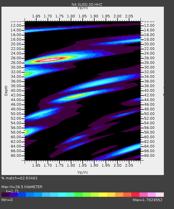
| Estimated Moho Depth: |
26.5 km |
| Estimated Crust Vp/Vs: |
1.71 |
| Assumed Crust Vp: |
6.53 km/s |
| Estimated Crust Vs: |
3.819 km/s |
| Estimated Crust Poisson's Ratio: |
0.24 |
|
| Radial Match: |
82.93463 % |
| Radial Bump: |
400 |
| Transverse Match: |
70.76138 % |
| Transverse Bump: |
400 |
| SOD ConfigId: |
26694651 |
| Insert Time: |
2022-01-25 01:25:17.173 +0000 |
| GWidth: |
2.5 |
| Max Bumps: |
400 |
| Tol: |
0.001 |
|

Signal To Noise
| Channel | StoN | STA | LTA |
| N4:SUSD:00:HHZ:20220111T01:20:10.309003Z | 6.376498 | 1.2335165E-6 | 1.9344732E-7 |
| N4:SUSD:00:HH1:20220111T01:20:10.309003Z | 1.0650249 | 4.3347586E-7 | 4.0701008E-7 |
| N4:SUSD:00:HH2:20220111T01:20:10.309003Z | 2.1426947 | 6.108048E-7 | 2.8506383E-7 |
| Arrivals |
| Ps | 2.9 SECOND |
| PpPs | 11 SECOND |
| PsPs/PpSs | 14 SECOND |


