You are here: Home > Network List > GS - US Geological Survey Networks Stations List
> Station ASL9 Albuquerque, New Mexico, USA > Earthquake Result Viewer
ASL9 Albuquerque, New Mexico, USA - Earthquake Result Viewer
| Earthquake location: |
Fox Islands, Aleutian Islands |
| Earthquake latitude/longitude: |
52.5/-167.7 |
| Earthquake time(UTC): |
2022/01/11 (011) 11:35:43 GMT |
| Earthquake Depth: |
0.5 km |
| Earthquake Magnitude: |
5.5 ml |
| Earthquake Catalog/Contributor: |
NEIC PDE/ak |
|
| Network: |
GS US Geological Survey Networks |
| Station: |
ASL9 Albuquerque, New Mexico, USA |
| Lat/Lon: |
34.95 N/106.46 W |
| Elevation: |
1820 m |
|
| Distance: |
46.2 deg |
| Az: |
87.111 deg |
| Baz: |
311.943 deg |
| Ray Param: |
0.07086431 |
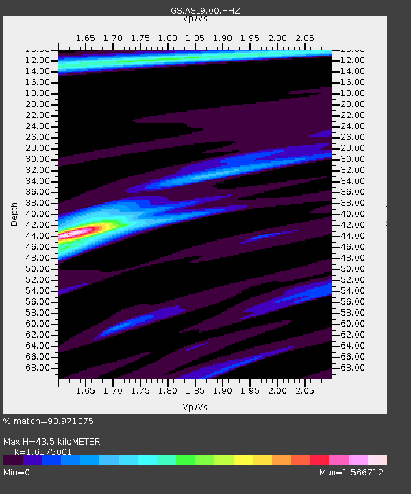
| Estimated Moho Depth: |
43.5 km |
| Estimated Crust Vp/Vs: |
1.62 |
| Assumed Crust Vp: |
6.502 km/s |
| Estimated Crust Vs: |
4.019 km/s |
| Estimated Crust Poisson's Ratio: |
0.19 |
|
| Radial Match: |
93.971375 % |
| Radial Bump: |
343 |
| Transverse Match: |
79.54724 % |
| Transverse Bump: |
400 |
| SOD ConfigId: |
26694651 |
| Insert Time: |
2022-01-25 11:45:26.977 +0000 |
| GWidth: |
2.5 |
| Max Bumps: |
400 |
| Tol: |
0.001 |
|

Signal To Noise
| Channel | StoN | STA | LTA |
| GS:ASL9:00:HHZ:20220111T11:43:39.017999Z | 4.182471 | 4.3614838E-7 | 1.0428008E-7 |
| GS:ASL9:00:HH1:20220111T11:43:39.017999Z | 1.1188557 | 1.6604407E-7 | 1.4840526E-7 |
| GS:ASL9:00:HH2:20220111T11:43:39.017999Z | 0.8696375 | 1.00338646E-7 | 1.15379855E-7 |
| Arrivals |
| Ps | 4.4 SECOND |
| PpPs | 16 SECOND |
| PsPs/PpSs | 21 SECOND |


