You are here: Home > Network List > N4 - Central and EAstern US Network Stations List
> Station I42A Draeger Farm, Ripon, WI, USA > Earthquake Result Viewer
I42A Draeger Farm, Ripon, WI, USA - Earthquake Result Viewer
| Earthquake location: |
Fox Islands, Aleutian Islands |
| Earthquake latitude/longitude: |
52.5/-167.7 |
| Earthquake time(UTC): |
2022/01/11 (011) 11:35:43 GMT |
| Earthquake Depth: |
0.5 km |
| Earthquake Magnitude: |
5.5 ml |
| Earthquake Catalog/Contributor: |
NEIC PDE/ak |
|
| Network: |
N4 Central and EAstern US Network |
| Station: |
I42A Draeger Farm, Ripon, WI, USA |
| Lat/Lon: |
43.89 N/88.91 W |
| Elevation: |
298 m |
|
| Distance: |
50.8 deg |
| Az: |
66.283 deg |
| Baz: |
309.216 deg |
| Ray Param: |
0.067857094 |
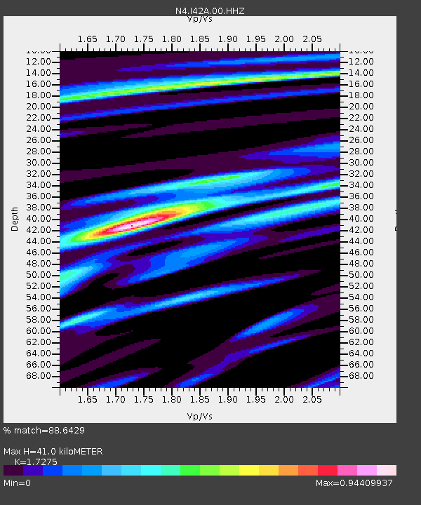
| Estimated Moho Depth: |
41.0 km |
| Estimated Crust Vp/Vs: |
1.73 |
| Assumed Crust Vp: |
6.571 km/s |
| Estimated Crust Vs: |
3.804 km/s |
| Estimated Crust Poisson's Ratio: |
0.25 |
|
| Radial Match: |
88.6429 % |
| Radial Bump: |
285 |
| Transverse Match: |
67.78929 % |
| Transverse Bump: |
400 |
| SOD ConfigId: |
26694651 |
| Insert Time: |
2022-01-25 11:50:31.700 +0000 |
| GWidth: |
2.5 |
| Max Bumps: |
400 |
| Tol: |
0.001 |
|

Signal To Noise
| Channel | StoN | STA | LTA |
| N4:I42A:00:HHZ:20220111T11:44:14.58001Z | 3.0206983 | 1.2153619E-6 | 4.0234468E-7 |
| N4:I42A:00:HH1:20220111T11:44:14.58001Z | 1.0660073 | 4.3673026E-7 | 4.0968789E-7 |
| N4:I42A:00:HH2:20220111T11:44:14.58001Z | 2.2990177 | 5.824216E-7 | 2.5333497E-7 |
| Arrivals |
| Ps | 4.8 SECOND |
| PpPs | 16 SECOND |
| PsPs/PpSs | 21 SECOND |


