You are here: Home > Network List > N4 - Central and EAstern US Network Stations List
> Station W52A Murphy, NC, USA > Earthquake Result Viewer
W52A Murphy, NC, USA - Earthquake Result Viewer
| Earthquake location: |
Fox Islands, Aleutian Islands |
| Earthquake latitude/longitude: |
52.5/-167.7 |
| Earthquake time(UTC): |
2022/01/11 (011) 11:35:43 GMT |
| Earthquake Depth: |
0.5 km |
| Earthquake Magnitude: |
5.5 ml |
| Earthquake Catalog/Contributor: |
NEIC PDE/ak |
|
| Network: |
N4 Central and EAstern US Network |
| Station: |
W52A Murphy, NC, USA |
| Lat/Lon: |
35.09 N/83.93 W |
| Elevation: |
519 m |
|
| Distance: |
59.5 deg |
| Az: |
71.049 deg |
| Baz: |
315.118 deg |
| Ray Param: |
0.06214972 |
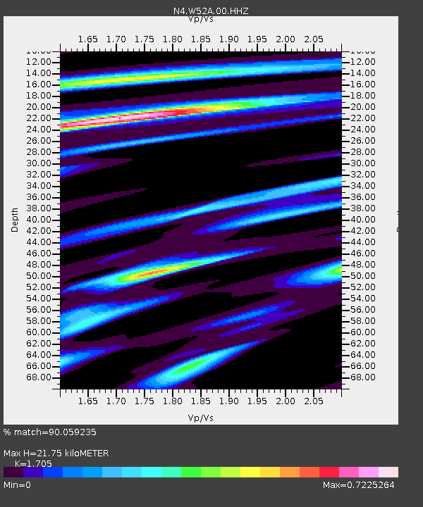
| Estimated Moho Depth: |
21.75 km |
| Estimated Crust Vp/Vs: |
1.71 |
| Assumed Crust Vp: |
6.35 km/s |
| Estimated Crust Vs: |
3.724 km/s |
| Estimated Crust Poisson's Ratio: |
0.24 |
|
| Radial Match: |
90.059235 % |
| Radial Bump: |
310 |
| Transverse Match: |
72.96439 % |
| Transverse Bump: |
400 |
| SOD ConfigId: |
26694651 |
| Insert Time: |
2022-01-25 11:51:57.093 +0000 |
| GWidth: |
2.5 |
| Max Bumps: |
400 |
| Tol: |
0.001 |
|

Signal To Noise
| Channel | StoN | STA | LTA |
| N4:W52A:00:HHZ:20220111T11:45:17.730004Z | 3.320198 | 1.0680575E-6 | 3.216849E-7 |
| N4:W52A:00:HH1:20220111T11:45:17.730004Z | 1.4003006 | 3.645711E-7 | 2.60352E-7 |
| N4:W52A:00:HH2:20220111T11:45:17.730004Z | 0.73845315 | 2.4132387E-7 | 3.2679645E-7 |
| Arrivals |
| Ps | 2.5 SECOND |
| PpPs | 8.8 SECOND |
| PsPs/PpSs | 11 SECOND |


