You are here: Home > Network List > XE05 - Sierra Nevada EarthScope Project- EarthScope Flex Array Stations List
> Station SNP47 SNP47 > Earthquake Result Viewer
SNP47 SNP47 - Earthquake Result Viewer
| Earthquake location: |
New Ireland Region, P.N.G. |
| Earthquake latitude/longitude: |
-4.5/153.5 |
| Earthquake time(UTC): |
2005/09/09 (252) 07:26:43 GMT |
| Earthquake Depth: |
90 km |
| Earthquake Magnitude: |
6.3 MB, 7.7 MW, 7.5 MW |
| Earthquake Catalog/Contributor: |
WHDF/NEIC |
|
| Network: |
XE Sierra Nevada EarthScope Project- EarthScope Flex Array |
| Station: |
SNP47 SNP47 |
| Lat/Lon: |
37.98 N/118.73 W |
| Elevation: |
2074 m |
|
| Distance: |
91.0 deg |
| Az: |
52.164 deg |
| Baz: |
265.088 deg |
| Ray Param: |
0.041614376 |
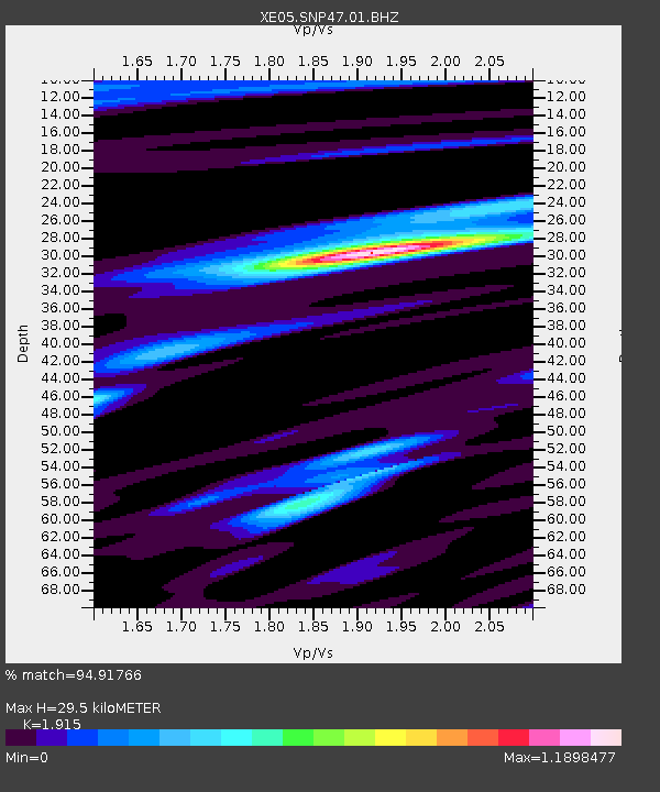
| Estimated Moho Depth: |
29.5 km |
| Estimated Crust Vp/Vs: |
1.91 |
| Assumed Crust Vp: |
6.291 km/s |
| Estimated Crust Vs: |
3.285 km/s |
| Estimated Crust Poisson's Ratio: |
0.31 |
|
| Radial Match: |
94.91766 % |
| Radial Bump: |
400 |
| Transverse Match: |
89.888725 % |
| Transverse Bump: |
400 |
| SOD ConfigId: |
268666 |
| Insert Time: |
2010-03-09 15:51:12.399 +0000 |
| GWidth: |
2.5 |
| Max Bumps: |
400 |
| Tol: |
0.001 |
|

Signal To Noise
| Channel | StoN | STA | LTA |
| XE:SNP47:01:BHZ:20050909T07:39:06.698994Z | 12.660013 | 9.692416E-7 | 7.655928E-8 |
| XE:SNP47:01:BHN:20050909T07:39:06.698994Z | 1.3231952 | 8.8207415E-8 | 6.666243E-8 |
| XE:SNP47:01:BHE:20050909T07:39:06.698994Z | 2.1741972 | 2.461986E-7 | 1.1323655E-7 |
| Arrivals |
| Ps | 4.4 SECOND |
| PpPs | 13 SECOND |
| PsPs/PpSs | 18 SECOND |


