You are here: Home > Network List > TX - Texas Seismological Network Stations List
> Station PLPT Palo Pinto > Earthquake Result Viewer
PLPT Palo Pinto - Earthquake Result Viewer
| Earthquake location: |
Fox Islands, Aleutian Islands |
| Earthquake latitude/longitude: |
52.5/-167.7 |
| Earthquake time(UTC): |
2022/01/11 (011) 11:35:43 GMT |
| Earthquake Depth: |
0.5 km |
| Earthquake Magnitude: |
5.5 ml |
| Earthquake Catalog/Contributor: |
NEIC PDE/ak |
|
| Network: |
TX Texas Seismological Network |
| Station: |
PLPT Palo Pinto |
| Lat/Lon: |
32.81 N/98.32 W |
| Elevation: |
336 m |
|
| Distance: |
52.6 deg |
| Az: |
83.088 deg |
| Baz: |
313.842 deg |
| Ray Param: |
0.06669815 |
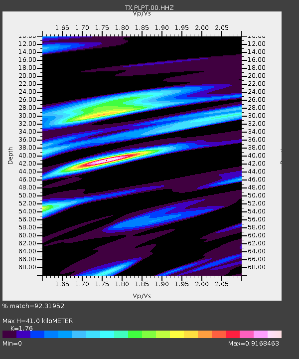
| Estimated Moho Depth: |
41.0 km |
| Estimated Crust Vp/Vs: |
1.76 |
| Assumed Crust Vp: |
6.426 km/s |
| Estimated Crust Vs: |
3.651 km/s |
| Estimated Crust Poisson's Ratio: |
0.26 |
|
| Radial Match: |
92.31952 % |
| Radial Bump: |
327 |
| Transverse Match: |
73.25067 % |
| Transverse Bump: |
400 |
| SOD ConfigId: |
26694651 |
| Insert Time: |
2022-01-25 11:59:43.286 +0000 |
| GWidth: |
2.5 |
| Max Bumps: |
400 |
| Tol: |
0.001 |
|

Signal To Noise
| Channel | StoN | STA | LTA |
| TX:PLPT:00:HHZ:20220111T11:44:27.925012Z | 2.3946993 | 4.9722314E-7 | 2.076349E-7 |
| TX:PLPT:00:HH1:20220111T11:44:27.925012Z | 1.1373032 | 2.2571409E-7 | 1.9846429E-7 |
| TX:PLPT:00:HH2:20220111T11:44:27.925012Z | 0.6873389 | 1.7513474E-7 | 2.5480117E-7 |
| Arrivals |
| Ps | 5.1 SECOND |
| PpPs | 17 SECOND |
| PsPs/PpSs | 22 SECOND |


