You are here: Home > Network List > UO - University of Oregon Regional Network Stations List
> Station RSBO Finn Rock, OR, USA > Earthquake Result Viewer
RSBO Finn Rock, OR, USA - Earthquake Result Viewer
| Earthquake location: |
Fox Islands, Aleutian Islands |
| Earthquake latitude/longitude: |
52.5/-167.7 |
| Earthquake time(UTC): |
2022/01/11 (011) 11:35:43 GMT |
| Earthquake Depth: |
0.5 km |
| Earthquake Magnitude: |
5.5 ml |
| Earthquake Catalog/Contributor: |
NEIC PDE/ak |
|
| Network: |
UO University of Oregon Regional Network |
| Station: |
RSBO Finn Rock, OR, USA |
| Lat/Lon: |
44.04 N/122.27 W |
| Elevation: |
1235 m |
|
| Distance: |
31.0 deg |
| Az: |
87.366 deg |
| Baz: |
302.059 deg |
| Ray Param: |
0.07926775 |
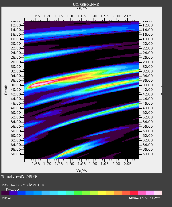
| Estimated Moho Depth: |
37.75 km |
| Estimated Crust Vp/Vs: |
1.65 |
| Assumed Crust Vp: |
6.566 km/s |
| Estimated Crust Vs: |
3.98 km/s |
| Estimated Crust Poisson's Ratio: |
0.21 |
|
| Radial Match: |
85.74979 % |
| Radial Bump: |
322 |
| Transverse Match: |
67.69074 % |
| Transverse Bump: |
400 |
| SOD ConfigId: |
26694651 |
| Insert Time: |
2022-01-25 12:00:23.210 +0000 |
| GWidth: |
2.5 |
| Max Bumps: |
400 |
| Tol: |
0.001 |
|

Signal To Noise
| Channel | StoN | STA | LTA |
| UO:RSBO: :HHZ:20220111T11:41:31.800012Z | 2.2030923 | 7.599909E-7 | 3.449655E-7 |
| UO:RSBO: :HHN:20220111T11:41:31.800012Z | 0.56998724 | 2.2928553E-7 | 4.0226433E-7 |
| UO:RSBO: :HHE:20220111T11:41:31.800012Z | 1.2031721 | 4.6004317E-7 | 3.8235856E-7 |
| Arrivals |
| Ps | 4.1 SECOND |
| PpPs | 14 SECOND |
| PsPs/PpSs | 18 SECOND |


