You are here: Home > Network List > IW - Intermountain West Stations List
> Station PLID Pearl Lake, Idaho, USA > Earthquake Result Viewer
PLID Pearl Lake, Idaho, USA - Earthquake Result Viewer
| Earthquake location: |
Fox Islands, Aleutian Islands |
| Earthquake latitude/longitude: |
52.5/-168.1 |
| Earthquake time(UTC): |
2022/01/11 (011) 12:39:36 GMT |
| Earthquake Depth: |
37 km |
| Earthquake Magnitude: |
6.5 Mi |
| Earthquake Catalog/Contributor: |
NEIC PDE/pt |
|
| Network: |
IW Intermountain West |
| Station: |
PLID Pearl Lake, Idaho, USA |
| Lat/Lon: |
45.09 N/116.00 W |
| Elevation: |
2164 m |
|
| Distance: |
34.4 deg |
| Az: |
81.158 deg |
| Baz: |
301.495 deg |
| Ray Param: |
0.07767508 |
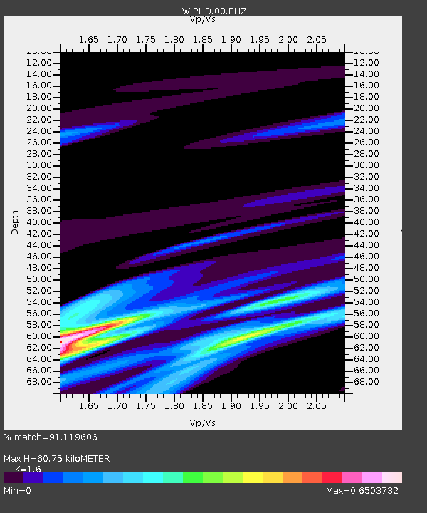
| Estimated Moho Depth: |
60.75 km |
| Estimated Crust Vp/Vs: |
1.60 |
| Assumed Crust Vp: |
6.571 km/s |
| Estimated Crust Vs: |
4.107 km/s |
| Estimated Crust Poisson's Ratio: |
0.18 |
|
| Radial Match: |
91.119606 % |
| Radial Bump: |
397 |
| Transverse Match: |
80.92409 % |
| Transverse Bump: |
400 |
| SOD ConfigId: |
26694651 |
| Insert Time: |
2022-01-25 12:49:18.769 +0000 |
| GWidth: |
2.5 |
| Max Bumps: |
400 |
| Tol: |
0.001 |
|

Signal To Noise
| Channel | StoN | STA | LTA |
| IW:PLID:00:BHZ:20220111T12:45:49.744995Z | 3.0295343 | 6.5474724E-6 | 2.161214E-6 |
| IW:PLID:00:BH1:20220111T12:45:49.744995Z | 0.3409506 | 7.4866205E-7 | 2.1958078E-6 |
| IW:PLID:00:BH2:20220111T12:45:49.744995Z | 2.8672383 | 4.7274993E-6 | 1.6487988E-6 |
| Arrivals |
| Ps | 6.1 SECOND |
| PpPs | 22 SECOND |
| PsPs/PpSs | 28 SECOND |


