You are here: Home > Network List > G - GEOSCOPE Stations List
> Station FOMA Nahampoana reservation, Fort Dauphin, Madagascar > Earthquake Result Viewer
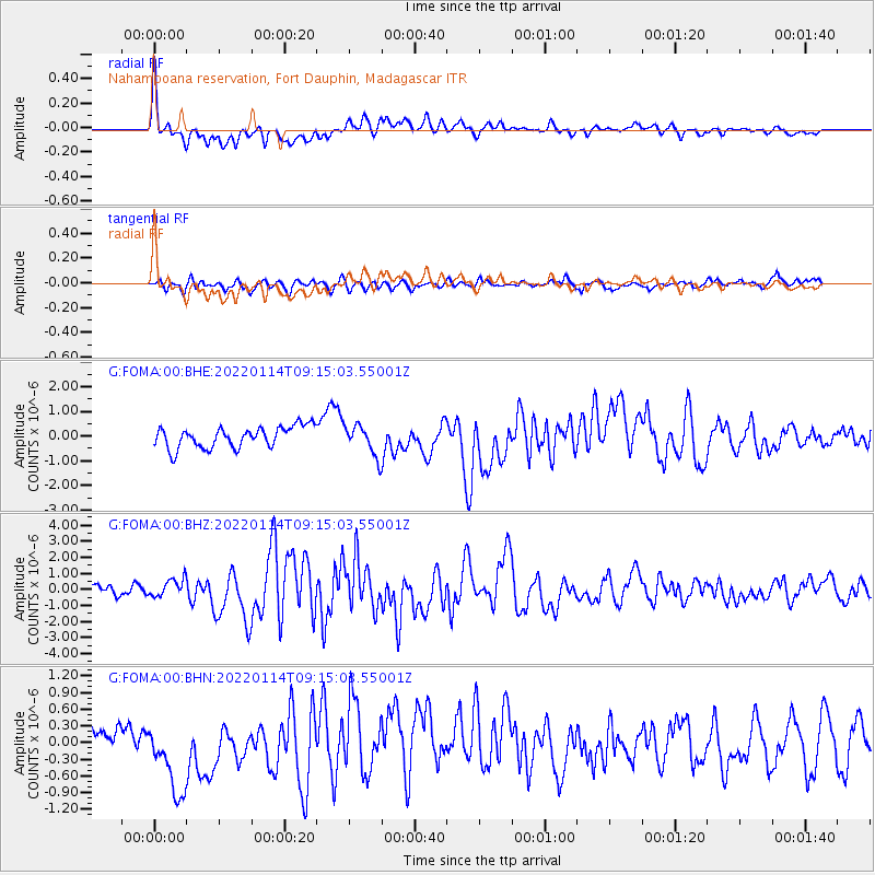
FOMA Nahampoana reservation, Fort Dauphin, Madagascar - Earthquake Result Viewer
*The percent match for this event was below the threshold and hence no stack was calculated.
| Earthquake location: |
Sunda Strait, Indonesia |
| Earthquake latitude/longitude: |
-6.9/105.3 |
| Earthquake time(UTC): |
2022/01/14 (014) 09:05:42 GMT |
| Earthquake Depth: |
37 km |
| Earthquake Magnitude: |
6.6 mww |
| Earthquake Catalog/Contributor: |
NEIC PDE/us |
|
| Network: |
G GEOSCOPE |
| Station: |
FOMA Nahampoana reservation, Fort Dauphin, Madagascar |
| Lat/Lon: |
24.98 S/46.98 E |
| Elevation: |
26 m |
|
| Distance: |
58.4 deg |
| Az: |
245.017 deg |
| Baz: |
82.547 deg |
| Ray Param: |
$rayparam |
*The percent match for this event was below the threshold and hence was not used in the summary stack. |
|
| Radial Match: |
66.170685 % |
| Radial Bump: |
400 |
| Transverse Match: |
39.95191 % |
| Transverse Bump: |
386 |
| SOD ConfigId: |
26694651 |
| Insert Time: |
2022-01-28 09:10:50.547 +0000 |
| GWidth: |
2.5 |
| Max Bumps: |
400 |
| Tol: |
0.001 |
|
Signal To Noise
| Channel | StoN | STA | LTA |
| G:FOMA:00:BHZ:20220114T09:15:03.55001Z | 1.7903582 | 5.5478824E-7 | 3.0987556E-7 |
| G:FOMA:00:BHN:20220114T09:15:03.55001Z | 4.6845427 | 8.222476E-7 | 1.7552357E-7 |
| G:FOMA:00:BHE:20220114T09:15:03.55001Z | 1.4553659 | 6.194577E-7 | 4.2563707E-7 |
| Arrivals |
| Ps | |
| PpPs | |
| PsPs/PpSs | |


