You are here: Home > Network List > GT - Global Telemetered Seismograph Network (USAF/USGS) Stations List
> Station BOSA Boshof, South Africa > Earthquake Result Viewer
BOSA Boshof, South Africa - Earthquake Result Viewer
| Earthquake location: |
Sunda Strait, Indonesia |
| Earthquake latitude/longitude: |
-6.9/105.3 |
| Earthquake time(UTC): |
2022/01/14 (014) 09:05:42 GMT |
| Earthquake Depth: |
37 km |
| Earthquake Magnitude: |
6.6 mww |
| Earthquake Catalog/Contributor: |
NEIC PDE/us |
|
| Network: |
GT Global Telemetered Seismograph Network (USAF/USGS) |
| Station: |
BOSA Boshof, South Africa |
| Lat/Lon: |
28.61 S/25.26 E |
| Elevation: |
1280 m |
|
| Distance: |
78.0 deg |
| Az: |
242.294 deg |
| Baz: |
91.359 deg |
| Ray Param: |
0.049927115 |
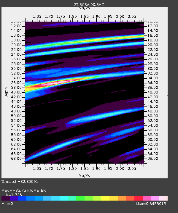
| Estimated Moho Depth: |
35.75 km |
| Estimated Crust Vp/Vs: |
1.74 |
| Assumed Crust Vp: |
6.459 km/s |
| Estimated Crust Vs: |
3.723 km/s |
| Estimated Crust Poisson's Ratio: |
0.25 |
|
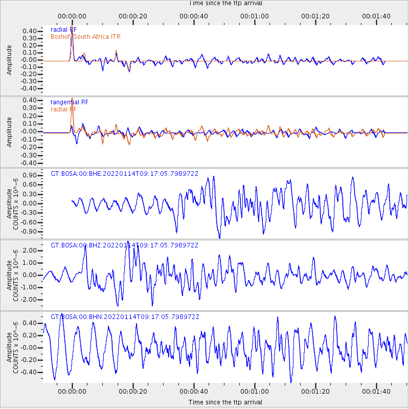
| Radial Match: |
82.33991 % |
| Radial Bump: |
386 |
| Transverse Match: |
62.39852 % |
| Transverse Bump: |
400 |
| SOD ConfigId: |
26694651 |
| Insert Time: |
2022-01-28 09:11:17.146 +0000 |
| GWidth: |
2.5 |
| Max Bumps: |
400 |
| Tol: |
0.001 |
|
Signal To Noise
| Channel | StoN | STA | LTA |
| GT:BOSA:00:BHZ:20220114T09:17:05.798972Z | 4.001046 | 9.0054E-7 | 2.2507612E-7 |
| GT:BOSA:00:BHN:20220114T09:17:05.798972Z | 0.9628445 | 2.4051857E-7 | 2.498E-7 |
| GT:BOSA:00:BHE:20220114T09:17:05.798972Z | 2.1565847 | 3.421809E-7 | 1.5866796E-7 |
| Arrivals |
| Ps | 4.2 SECOND |
| PpPs | 15 SECOND |
| PsPs/PpSs | 19 SECOND |


