You are here: Home > Network List > IU - Global Seismograph Network (GSN - IRIS/USGS) Stations List
> Station KBL Kabul, Afghanistan > Earthquake Result Viewer
KBL Kabul, Afghanistan - Earthquake Result Viewer
| Earthquake location: |
Sunda Strait, Indonesia |
| Earthquake latitude/longitude: |
-6.9/105.3 |
| Earthquake time(UTC): |
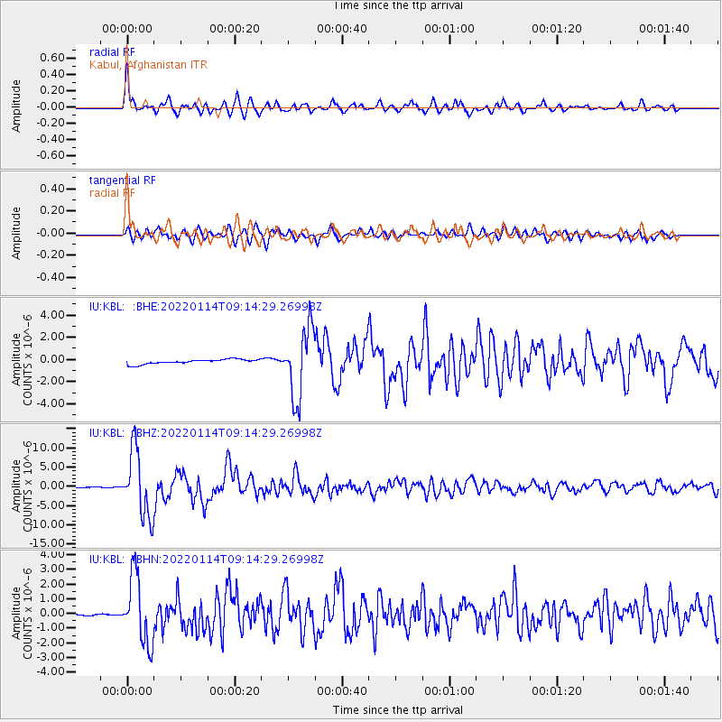
2022/01/14 (014) 09:05:42 GMT |
| Earthquake Depth: |
37 km |
| Earthquake Magnitude: |
6.6 mww |
| Earthquake Catalog/Contributor: |
NEIC PDE/us |
|
| Network: |
IU Global Seismograph Network (GSN - IRIS/USGS) |
| Station: |
KBL Kabul, Afghanistan |
| Lat/Lon: |
34.54 N/69.04 E |
| Elevation: |
1920 m |
|
| Distance: |
53.6 deg |
| Az: |
322.702 deg |
| Baz: |
133.217 deg |
| Ray Param: |
0.065934114 |
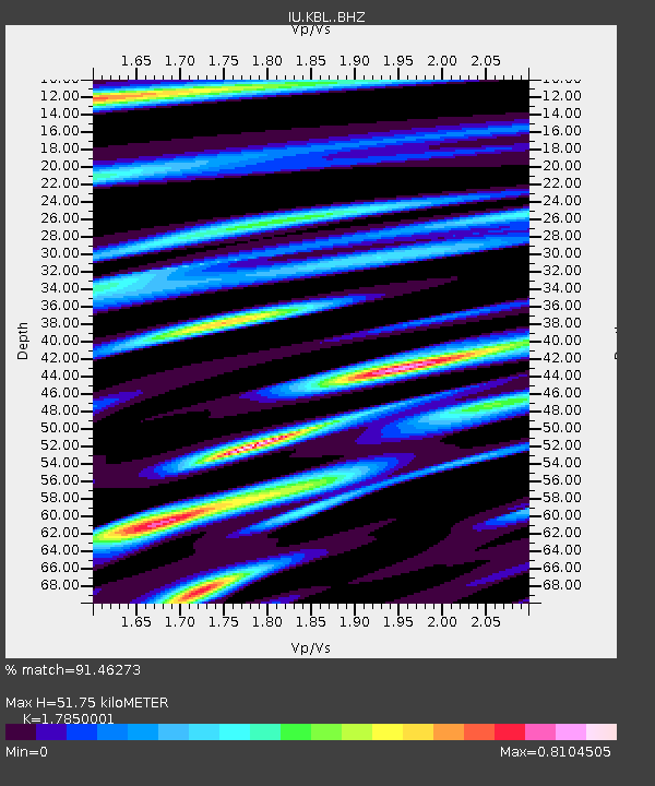
| Estimated Moho Depth: |
51.75 km |
| Estimated Crust Vp/Vs: |
1.79 |
| Assumed Crust Vp: |
6.641 km/s |
| Estimated Crust Vs: |
3.72 km/s |
| Estimated Crust Poisson's Ratio: |
0.27 |
|
| Radial Match: |
91.46273 % |
| Radial Bump: |
400 |
| Transverse Match: |
81.48292 % |
| Transverse Bump: |
400 |
| SOD ConfigId: |
26694651 |
| Insert Time: |
2022-01-28 09:12:18.091 +0000 |
| GWidth: |
2.5 |
| Max Bumps: |
400 |
| Tol: |
0.001 |
|
Signal To Noise
| Channel | StoN | STA | LTA |
| IU:KBL: :BHZ:20220114T09:14:29.26998Z | 91.41021 | 8.682103E-6 | 9.497957E-8 |
| IU:KBL: :BHN:20220114T09:14:29.26998Z | 36.897186 | 2.3460245E-6 | 6.358275E-8 |
| IU:KBL: :BHE:20220114T09:14:29.26998Z | 15.388554 | 3.1587426E-6 | 2.0526574E-7 |
| Arrivals |
| Ps | 6.5 SECOND |
| PpPs | 20 SECOND |
| PsPs/PpSs | 27 SECOND |


