You are here: Home > Network List > JP - Japan Meteorological Agency Seismic Network Stations List
> Station JNU Oita Nakatsue > Earthquake Result Viewer
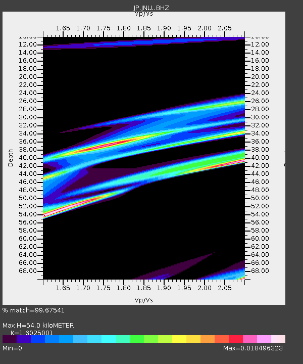
JNU Oita Nakatsue - Earthquake Result Viewer
| Earthquake location: |
Sunda Strait, Indonesia |
| Earthquake latitude/longitude: |
-6.9/105.3 |
| Earthquake time(UTC): |
2022/01/14 (014) 09:05:42 GMT |
| Earthquake Depth: |
37 km |
| Earthquake Magnitude: |
6.6 mww |
| Earthquake Catalog/Contributor: |
NEIC PDE/us |
|
| Network: |
JP Japan Meteorological Agency Seismic Network |
| Station: |
JNU Oita Nakatsue |
| Lat/Lon: |
33.12 N/130.88 E |
| Elevation: |
540 m |
|
| Distance: |
46.7 deg |
| Az: |
29.919 deg |
| Baz: |
216.164 deg |
| Ray Param: |
0.07041299 |
| Estimated Moho Depth: |
54.0 km |
| Estimated Crust Vp/Vs: |
1.60 |
| Assumed Crust Vp: |
6.468 km/s |
| Estimated Crust Vs: |
4.036 km/s |
| Estimated Crust Poisson's Ratio: |
0.18 |
|
| Radial Match: |
99.67541 % |
| Radial Bump: |
46 |
| Transverse Match: |
95.32394 % |
| Transverse Bump: |
224 |
| SOD ConfigId: |
26694651 |
| Insert Time: |
2022-01-28 09:12:43.362 +0000 |
| GWidth: |
2.5 |
| Max Bumps: |
400 |
| Tol: |
0.001 |
|

Signal To Noise
| Channel | StoN | STA | LTA |
| JP:JNU: :BHZ:20220114T09:13:37.149985Z | 3.060978 | 5.0540905E-8 | 1.651136E-8 |
| JP:JNU: :BHN:20220114T09:13:37.149985Z | 3.027929 | 5.058848E-8 | 1.6707286E-8 |
| JP:JNU: :BHE:20220114T09:13:37.149985Z | 3.0512238 | 4.9943733E-8 | 1.6368428E-8 |
| Arrivals |
| Ps | 5.4 SECOND |
| PpPs | 20 SECOND |
| PsPs/PpSs | 26 SECOND |


