You are here: Home > Network List > KR - Kyrgyz Digital Network Stations List
> Station TRKS Terek-Say, Kyrgyzstan > Earthquake Result Viewer
TRKS Terek-Say, Kyrgyzstan - Earthquake Result Viewer
| Earthquake location: |
Sunda Strait, Indonesia |
| Earthquake latitude/longitude: |
-6.9/105.3 |
| Earthquake time(UTC): |
2022/01/14 (014) 09:05:42 GMT |
| Earthquake Depth: |
37 km |
| Earthquake Magnitude: |
6.6 mww |
| Earthquake Catalog/Contributor: |
NEIC PDE/us |
|
| Network: |
KR Kyrgyz Digital Network |
| Station: |
TRKS Terek-Say, Kyrgyzstan |
| Lat/Lon: |
41.46 N/71.17 E |
| Elevation: |
1518 m |
|
| Distance: |
57.4 deg |
| Az: |
330.002 deg |
| Baz: |
138.668 deg |
| Ray Param: |
0.06346234 |
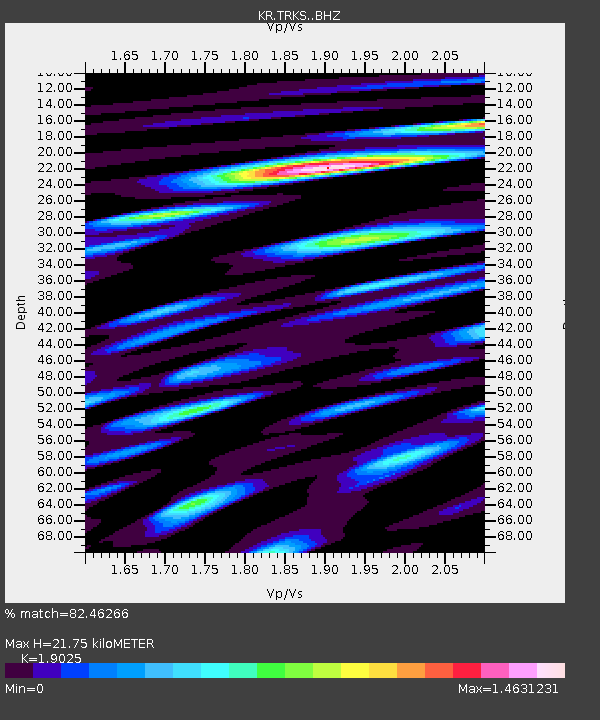
| Estimated Moho Depth: |
21.75 km |
| Estimated Crust Vp/Vs: |
1.90 |
| Assumed Crust Vp: |
6.236 km/s |
| Estimated Crust Vs: |
3.278 km/s |
| Estimated Crust Poisson's Ratio: |
0.31 |
|
| Radial Match: |
82.46266 % |
| Radial Bump: |
400 |
| Transverse Match: |
66.57541 % |
| Transverse Bump: |
400 |
| SOD ConfigId: |
26694651 |
| Insert Time: |
2022-01-28 09:13:31.358 +0000 |
| GWidth: |
2.5 |
| Max Bumps: |
400 |
| Tol: |
0.001 |
|

Signal To Noise
| Channel | StoN | STA | LTA |
| KR:TRKS: :BHZ:20220114T09:14:56.51998Z | 84.168015 | 7.0916954E-6 | 8.425642E-8 |
| KR:TRKS: :BHN:20220114T09:14:56.51998Z | 26.836584 | 2.949052E-6 | 1.0988924E-7 |
| KR:TRKS: :BHE:20220114T09:14:56.51998Z | 19.470484 | 2.6648963E-6 | 1.3686852E-7 |
| Arrivals |
| Ps | 3.3 SECOND |
| PpPs | 9.7 SECOND |
| PsPs/PpSs | 13 SECOND |


