You are here: Home > Network List > IU - Global Seismograph Network (GSN - IRIS/USGS) Stations List
> Station ULN Ulaanbaatar, Mongolia > Earthquake Result Viewer
ULN Ulaanbaatar, Mongolia - Earthquake Result Viewer

| Earthquake location: |
Southwest Of Sumatra, Indonesia |
| Earthquake latitude/longitude: |
-2.1/98.5 |
| Earthquake time(UTC): |
2018/06/12 (163) 23:08:28 GMT |
| Earthquake Depth: |
10 km |
| Earthquake Magnitude: |
5.8 Mww |
| Earthquake Catalog/Contributor: |
NEIC PDE/us |
|
| Network: |
IU Global Seismograph Network (GSN - IRIS/USGS) |
| Station: |
ULN Ulaanbaatar, Mongolia |
| Lat/Lon: |
47.87 N/107.05 E |
| Elevation: |
1610 m |
|
| Distance: |
50.3 deg |
| Az: |
7.459 deg |
| Baz: |
191.109 deg |
| Ray Param: |
0.06813927 |
| Estimated Moho Depth: |
47.0 km |
| Estimated Crust Vp/Vs: |
1.69 |
| Assumed Crust Vp: |
6.642 km/s |
| Estimated Crust Vs: |
3.942 km/s |
| Estimated Crust Poisson's Ratio: |
0.23 |
|
| Radial Match: |
97.753914 % |
| Radial Bump: |
283 |
| Transverse Match: |
80.10562 % |
| Transverse Bump: |
400 |
| SOD ConfigId: |
2709371 |
| Insert Time: |
2018-06-26 23:10:36.812 +0000 |
| GWidth: |
2.5 |
| Max Bumps: |
400 |
| Tol: |
0.001 |
|
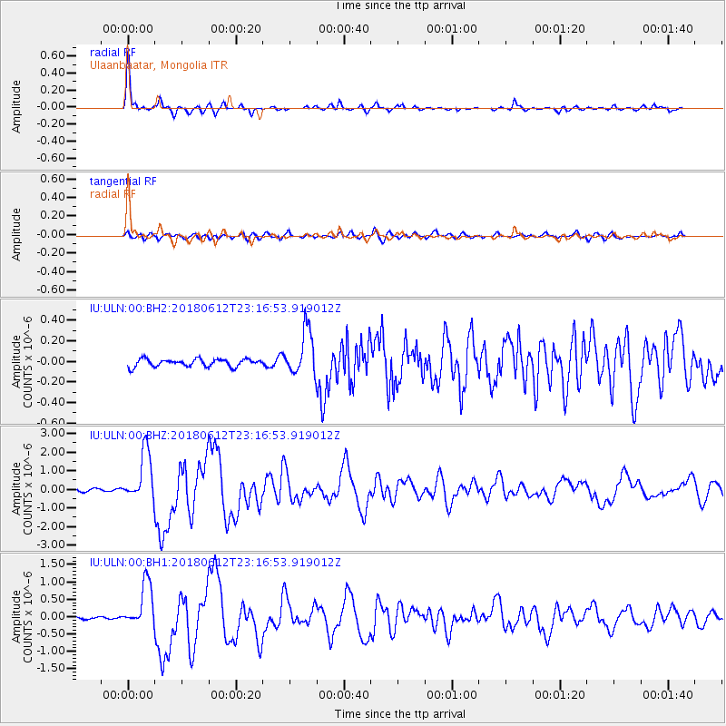
Signal To Noise
| Channel | StoN | STA | LTA |
| IU:ULN:00:BHZ:20180612T23:16:53.919012Z | 19.627884 | 1.3403966E-6 | 6.8290426E-8 |
| IU:ULN:00:BH1:20180612T23:16:53.919012Z | 23.380756 | 6.56454E-7 | 2.8076677E-8 |
| IU:ULN:00:BH2:20180612T23:16:53.919012Z | 5.983548 | 2.1952593E-7 | 3.6688252E-8 |
| Arrivals |
| Ps | 5.2 SECOND |
| PpPs | 18 SECOND |
| PsPs/PpSs | 23 SECOND |


