You are here: Home > Network List > O2 - Oklahoma Consolidated Temporary Seismic Networks Stations List
> Station CVNG Covington, Oklahoma, USA > Earthquake Result Viewer
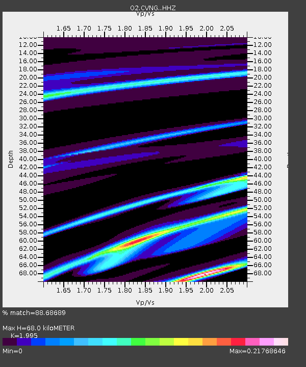
CVNG Covington, Oklahoma, USA - Earthquake Result Viewer
| Earthquake location: |
Tonga Islands |
| Earthquake latitude/longitude: |
-20.5/-175.4 |
| Earthquake time(UTC): |
2022/01/15 (015) 04:14:45 GMT |
| Earthquake Depth: |
0.0 km |
| Earthquake Magnitude: |
5.8 Ms_20 |
| Earthquake Catalog/Contributor: |
NEIC PDE/us |
|
| Network: |
O2 Oklahoma Consolidated Temporary Seismic Networks |
| Station: |
CVNG Covington, Oklahoma, USA |
| Lat/Lon: |
36.32 N/97.43 W |
| Elevation: |
358 m |
|
| Distance: |
92.7 deg |
| Az: |
52.256 deg |
| Baz: |
246.575 deg |
| Ray Param: |
0.041409045 |
| Estimated Moho Depth: |
68.0 km |
| Estimated Crust Vp/Vs: |
2.00 |
| Assumed Crust Vp: |
6.483 km/s |
| Estimated Crust Vs: |
3.249 km/s |
| Estimated Crust Poisson's Ratio: |
0.33 |
|
| Radial Match: |
88.68689 % |
| Radial Bump: |
204 |
| Transverse Match: |
69.16429 % |
| Transverse Bump: |
400 |
| SOD ConfigId: |
26694651 |
| Insert Time: |
2022-01-29 04:29:13.861 +0000 |
| GWidth: |
2.5 |
| Max Bumps: |
400 |
| Tol: |
0.001 |
|

Signal To Noise
| Channel | StoN | STA | LTA |
| O2:CVNG: :HHZ:20220115T04:27:27.340027Z | 2.5822413 | 4.801672E-6 | 1.8594978E-6 |
| O2:CVNG: :HHN:20220115T04:27:27.340027Z | 3.0891185 | 4.075414E-6 | 1.3192806E-6 |
| O2:CVNG: :HHE:20220115T04:27:27.340027Z | 1.2395966 | 1.2690083E-6 | 1.0237268E-6 |
| Arrivals |
| Ps | 11 SECOND |
| PpPs | 31 SECOND |
| PsPs/PpSs | 41 SECOND |


