You are here: Home > Network List > US - United States National Seismic Network Stations List
> Station DGMT Dagmar, Montana, USA > Earthquake Result Viewer
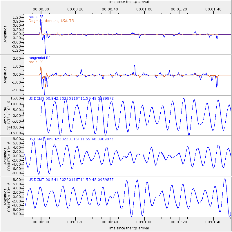
DGMT Dagmar, Montana, USA - Earthquake Result Viewer
*The percent match for this event was below the threshold and hence no stack was calculated.
| Earthquake location: |
Aegean Sea |
| Earthquake latitude/longitude: |
40.1/24.4 |
| Earthquake time(UTC): |
2022/01/16 (016) 11:48:05 GMT |
| Earthquake Depth: |
10 km |
| Earthquake Magnitude: |
5.5 mww |
| Earthquake Catalog/Contributor: |
NEIC PDE/us |
|
| Network: |
US United States National Seismic Network |
| Station: |
DGMT Dagmar, Montana, USA |
| Lat/Lon: |
48.47 N/104.20 W |
| Elevation: |
0.0 m |
|
| Distance: |
80.8 deg |
| Az: |
328.186 deg |
| Baz: |
37.448 deg |
| Ray Param: |
$rayparam |
*The percent match for this event was below the threshold and hence was not used in the summary stack. |
|
| Radial Match: |
93.10741 % |
| Radial Bump: |
239 |
| Transverse Match: |
70.086685 % |
| Transverse Bump: |
400 |
| SOD ConfigId: |
26694651 |
| Insert Time: |
2022-01-30 12:10:00.067 +0000 |
| GWidth: |
2.5 |
| Max Bumps: |
400 |
| Tol: |
0.001 |
|
Signal To Noise
| Channel | StoN | STA | LTA |
| US:DGMT:00:BHZ:20220116T11:59:48.098987Z | 2.8861394 | 6.1663436E-6 | 2.136537E-6 |
| US:DGMT:00:BH1:20220116T11:59:48.098987Z | 0.82930267 | 3.18027E-6 | 3.8348726E-6 |
| US:DGMT:00:BH2:20220116T11:59:48.098987Z | 1.1594046 | 1.1148292E-5 | 9.615532E-6 |
| Arrivals |
| Ps | |
| PpPs | |
| PsPs/PpSs | |


