You are here: Home > Network List > US - United States National Seismic Network Stations List
> Station WMOK Wichita Mountains, Oklahoma, USA > Earthquake Result Viewer
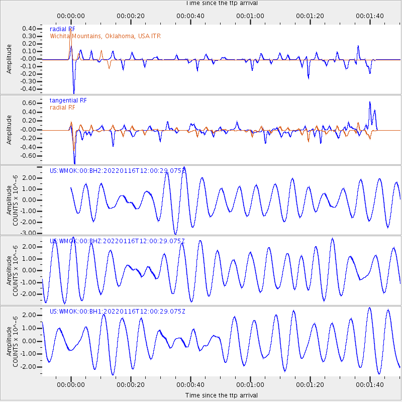
WMOK Wichita Mountains, Oklahoma, USA - Earthquake Result Viewer
*The percent match for this event was below the threshold and hence no stack was calculated.
| Earthquake location: |
Aegean Sea |
| Earthquake latitude/longitude: |
40.1/24.4 |
| Earthquake time(UTC): |
2022/01/16 (016) 11:48:05 GMT |
| Earthquake Depth: |
10 km |
| Earthquake Magnitude: |
5.5 mww |
| Earthquake Catalog/Contributor: |
NEIC PDE/us |
|
| Network: |
US United States National Seismic Network |
| Station: |
WMOK Wichita Mountains, Oklahoma, USA |
| Lat/Lon: |
34.74 N/98.78 W |
| Elevation: |
486 m |
|
| Distance: |
89.0 deg |
| Az: |
316.398 deg |
| Baz: |
40.0 deg |
| Ray Param: |
$rayparam |
*The percent match for this event was below the threshold and hence was not used in the summary stack. |
|
| Radial Match: |
86.73812 % |
| Radial Bump: |
373 |
| Transverse Match: |
82.56183 % |
| Transverse Bump: |
394 |
| SOD ConfigId: |
26694651 |
| Insert Time: |
2022-01-30 12:10:26.367 +0000 |
| GWidth: |
2.5 |
| Max Bumps: |
400 |
| Tol: |
0.001 |
|
Signal To Noise
| Channel | StoN | STA | LTA |
| US:WMOK:00:BHZ:20220116T12:00:29.075Z | 1.4247988 | 1.9393374E-6 | 1.3611306E-6 |
| US:WMOK:00:BH1:20220116T12:00:29.075Z | 0.53465724 | 5.736345E-7 | 1.0729016E-6 |
| US:WMOK:00:BH2:20220116T12:00:29.075Z | 2.2232313 | 1.7708476E-6 | 7.965197E-7 |
| Arrivals |
| Ps | |
| PpPs | |
| PsPs/PpSs | |


