You are here: Home > Network List > UU - University of Utah Regional Network Stations List
> Station CCUT Cedar City, UT, USA > Earthquake Result Viewer
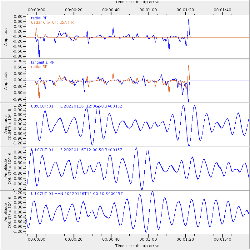
CCUT Cedar City, UT, USA - Earthquake Result Viewer
*The percent match for this event was below the threshold and hence no stack was calculated.
| Earthquake location: |
Aegean Sea |
| Earthquake latitude/longitude: |
40.1/24.4 |
| Earthquake time(UTC): |
2022/01/16 (016) 11:48:05 GMT |
| Earthquake Depth: |
10 km |
| Earthquake Magnitude: |
5.5 mww |
| Earthquake Catalog/Contributor: |
NEIC PDE/us |
|
| Network: |
UU University of Utah Regional Network |
| Station: |
CCUT Cedar City, UT, USA |
| Lat/Lon: |
37.55 N/113.36 W |
| Elevation: |
2127 m |
|
| Distance: |
93.6 deg |
| Az: |
327.612 deg |
| Baz: |
31.153 deg |
| Ray Param: |
$rayparam |
*The percent match for this event was below the threshold and hence was not used in the summary stack. |
|
| Radial Match: |
78.17456 % |
| Radial Bump: |
392 |
| Transverse Match: |
48.118896 % |
| Transverse Bump: |
400 |
| SOD ConfigId: |
26694651 |
| Insert Time: |
2022-01-30 12:10:28.918 +0000 |
| GWidth: |
2.5 |
| Max Bumps: |
400 |
| Tol: |
0.001 |
|
Signal To Noise
| Channel | StoN | STA | LTA |
| UU:CCUT:01:HHZ:20220116T12:00:50.340015Z | 0.99920934 | 6.094546E-7 | 6.099369E-7 |
| UU:CCUT:01:HHN:20220116T12:00:50.340015Z | 0.947551 | 4.609719E-7 | 4.8648764E-7 |
| UU:CCUT:01:HHE:20220116T12:00:50.340015Z | 2.0155222 | 8.9334634E-7 | 4.4323315E-7 |
| Arrivals |
| Ps | |
| PpPs | |
| PsPs/PpSs | |


