You are here: Home > Network List > AK - Alaska Regional Network Stations List
> Station L18K Granite Mountain, AK, USA > Earthquake Result Viewer
L18K Granite Mountain, AK, USA - Earthquake Result Viewer
| Earthquake location: |
Solomon Islands |
| Earthquake latitude/longitude: |
-6.4/154.8 |
| Earthquake time(UTC): |
2022/01/16 (016) 12:52:10 GMT |
| Earthquake Depth: |
408 km |
| Earthquake Magnitude: |
6.1 Mww |
| Earthquake Catalog/Contributor: |
NEIC PDE/us |
|
| Network: |
AK Alaska Regional Network |
| Station: |
L18K Granite Mountain, AK, USA |
| Lat/Lon: |
62.22 N/156.69 W |
| Elevation: |
329 m |
|
| Distance: |
77.9 deg |
| Az: |
21.031 deg |
| Baz: |
229.567 deg |
| Ray Param: |
0.048862346 |
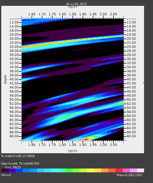
| Estimated Moho Depth: |
69.75 km |
| Estimated Crust Vp/Vs: |
1.89 |
| Assumed Crust Vp: |
6.182 km/s |
| Estimated Crust Vs: |
3.267 km/s |
| Estimated Crust Poisson's Ratio: |
0.31 |
|
| Radial Match: |
85.210655 % |
| Radial Bump: |
341 |
| Transverse Match: |
60.245964 % |
| Transverse Bump: |
400 |
| SOD ConfigId: |
26694651 |
| Insert Time: |
2022-01-30 12:54:56.776 +0000 |
| GWidth: |
2.5 |
| Max Bumps: |
400 |
| Tol: |
0.001 |
|

Signal To Noise
| Channel | StoN | STA | LTA |
| AK:L18K: :BHZ:20220116T13:02:53.499992Z | 3.023108 | 9.930164E-7 | 3.2847532E-7 |
| AK:L18K: :BHN:20220116T13:02:53.499992Z | 0.98772645 | 3.1653707E-7 | 3.2047038E-7 |
| AK:L18K: :BHE:20220116T13:02:53.499992Z | 1.1328399 | 3.1871232E-7 | 2.8133925E-7 |
| Arrivals |
| Ps | 10 SECOND |
| PpPs | 32 SECOND |
| PsPs/PpSs | 42 SECOND |


