You are here: Home > Network List > US - United States National Seismic Network Stations List
> Station WMOK Wichita Mountains, Oklahoma, USA > Earthquake Result Viewer
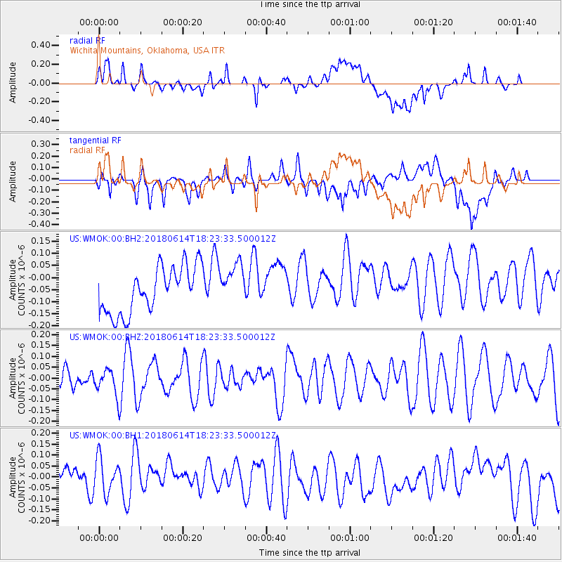
WMOK Wichita Mountains, Oklahoma, USA - Earthquake Result Viewer
*The percent match for this event was below the threshold and hence no stack was calculated.
| Earthquake location: |
Central Mid-Atlantic Ridge |
| Earthquake latitude/longitude: |
1.1/-25.7 |
| Earthquake time(UTC): |
2018/06/14 (165) 18:12:20 GMT |
| Earthquake Depth: |
10 km |
| Earthquake Magnitude: |
5.6 Mww |
| Earthquake Catalog/Contributor: |
NEIC PDE/us |
|
| Network: |
US United States National Seismic Network |
| Station: |
WMOK Wichita Mountains, Oklahoma, USA |
| Lat/Lon: |
34.74 N/98.78 W |
| Elevation: |
486 m |
|
| Distance: |
75.5 deg |
| Az: |
305.528 deg |
| Baz: |
98.877 deg |
| Ray Param: |
$rayparam |
*The percent match for this event was below the threshold and hence was not used in the summary stack. |
|
| Radial Match: |
43.11193 % |
| Radial Bump: |
400 |
| Transverse Match: |
40.981636 % |
| Transverse Bump: |
400 |
| SOD ConfigId: |
2709371 |
| Insert Time: |
2018-06-28 18:20:30.631 +0000 |
| GWidth: |
2.5 |
| Max Bumps: |
400 |
| Tol: |
0.001 |
|
Signal To Noise
| Channel | StoN | STA | LTA |
| US:WMOK:00:BHZ:20180614T18:23:33.500012Z | 0.6644589 | 6.381351E-8 | 9.603831E-8 |
| US:WMOK:00:BH1:20180614T18:23:33.500012Z | 1.2550182 | 8.717493E-8 | 6.946108E-8 |
| US:WMOK:00:BH2:20180614T18:23:33.500012Z | 0.8933325 | 8.488784E-8 | 9.5023786E-8 |
| Arrivals |
| Ps | |
| PpPs | |
| PsPs/PpSs | |


