You are here: Home > Network List > XE05 - Sierra Nevada EarthScope Project- EarthScope Flex Array Stations List
> Station SNP51 SNP51 > Earthquake Result Viewer
SNP51 SNP51 - Earthquake Result Viewer
| Earthquake location: |
Chile-Bolivia Border Region |
| Earthquake latitude/longitude: |
-22.3/-67.9 |
| Earthquake time(UTC): |
2005/11/17 (321) 19:26:56 GMT |
| Earthquake Depth: |
163 km |
| Earthquake Magnitude: |
6.0 MB, 6.9 MW, 6.8 MW |
| Earthquake Catalog/Contributor: |
WHDF/NEIC |
|
| Network: |
XE Sierra Nevada EarthScope Project- EarthScope Flex Array |
| Station: |
SNP51 SNP51 |
| Lat/Lon: |
37.25 N/120.06 W |
| Elevation: |
250 m |
|
| Distance: |
77.0 deg |
| Az: |
319.691 deg |
| Baz: |
131.347 deg |
| Ray Param: |
0.050235733 |
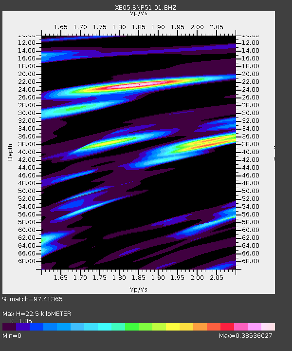
| Estimated Moho Depth: |
22.5 km |
| Estimated Crust Vp/Vs: |
1.85 |
| Assumed Crust Vp: |
6.391 km/s |
| Estimated Crust Vs: |
3.454 km/s |
| Estimated Crust Poisson's Ratio: |
0.29 |
|
| Radial Match: |
97.41365 % |
| Radial Bump: |
311 |
| Transverse Match: |
92.758575 % |
| Transverse Bump: |
400 |
| SOD ConfigId: |
268666 |
| Insert Time: |
2010-03-09 15:57:00.737 +0000 |
| GWidth: |
2.5 |
| Max Bumps: |
400 |
| Tol: |
0.001 |
|

Signal To Noise
| Channel | StoN | STA | LTA |
| XE:SNP51:01:BHZ:20051117T19:38:00.015022Z | 74.919785 | 6.8835843E-6 | 9.187939E-8 |
| XE:SNP51:01:BHN:20051117T19:38:00.015022Z | 18.774446 | 2.1937815E-6 | 1.1684932E-7 |
| XE:SNP51:01:BHE:20051117T19:38:00.015022Z | 22.949438 | 2.385962E-6 | 1.0396604E-7 |
| Arrivals |
| Ps | 3.1 SECOND |
| PpPs | 9.7 SECOND |
| PsPs/PpSs | 13 SECOND |


