You are here: Home > Network List > AV - Alaska Volcano Observatory Stations List
> Station AMKA Regional Station, Amchitka Island, Alaska > Earthquake Result Viewer
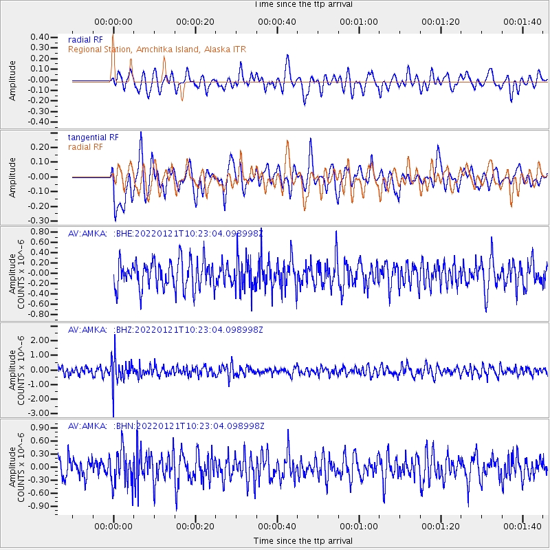
AMKA Regional Station, Amchitka Island, Alaska - Earthquake Result Viewer
*The percent match for this event was below the threshold and hence no stack was calculated.
| Earthquake location: |
Myanmar-India Border Region |
| Earthquake latitude/longitude: |
23.1/93.7 |
| Earthquake time(UTC): |
2022/01/21 (021) 10:12:31 GMT |
| Earthquake Depth: |
57 km |
| Earthquake Magnitude: |
5.4 Mww |
| Earthquake Catalog/Contributor: |
NEIC PDE/us |
|
| Network: |
AV Alaska Volcano Observatory |
| Station: |
AMKA Regional Station, Amchitka Island, Alaska |
| Lat/Lon: |
51.38 N/179.30 E |
| Elevation: |
116 m |
|
| Distance: |
69.6 deg |
| Az: |
41.805 deg |
| Baz: |
281.613 deg |
| Ray Param: |
$rayparam |
*The percent match for this event was below the threshold and hence was not used in the summary stack. |
|
| Radial Match: |
43.33992 % |
| Radial Bump: |
400 |
| Transverse Match: |
50.733955 % |
| Transverse Bump: |
400 |
| SOD ConfigId: |
26694651 |
| Insert Time: |
2022-02-04 10:17:32.596 +0000 |
| GWidth: |
2.5 |
| Max Bumps: |
400 |
| Tol: |
0.001 |
|
Signal To Noise
| Channel | StoN | STA | LTA |
| AV:AMKA: :BHZ:20220121T10:23:04.098998Z | 3.4460077 | 8.737423E-7 | 2.5355203E-7 |
| AV:AMKA: :BHN:20220121T10:23:04.098998Z | 1.720215 | 4.0576057E-7 | 2.3587783E-7 |
| AV:AMKA: :BHE:20220121T10:23:04.098998Z | 1.1238325 | 2.9994246E-7 | 2.668925E-7 |
| Arrivals |
| Ps | |
| PpPs | |
| PsPs/PpSs | |


