You are here: Home > Network List > IU - Global Seismograph Network (GSN - IRIS/USGS) Stations List
> Station CTAO Charters Towers, Australia > Earthquake Result Viewer
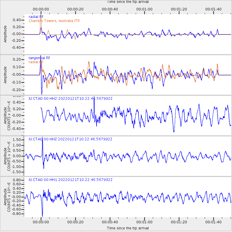
CTAO Charters Towers, Australia - Earthquake Result Viewer
*The percent match for this event was below the threshold and hence no stack was calculated.
| Earthquake location: |
Myanmar-India Border Region |
| Earthquake latitude/longitude: |
23.1/93.7 |
| Earthquake time(UTC): |
2022/01/21 (021) 10:12:31 GMT |
| Earthquake Depth: |
57 km |
| Earthquake Magnitude: |
5.4 Mww |
| Earthquake Catalog/Contributor: |
NEIC PDE/us |
|
| Network: |
IU Global Seismograph Network (GSN - IRIS/USGS) |
| Station: |
CTAO Charters Towers, Australia |
| Lat/Lon: |
20.09 S/146.25 E |
| Elevation: |
367 m |
|
| Distance: |
66.8 deg |
| Az: |
125.772 deg |
| Baz: |
307.346 deg |
| Ray Param: |
$rayparam |
*The percent match for this event was below the threshold and hence was not used in the summary stack. |
|
| Radial Match: |
48.83474 % |
| Radial Bump: |
400 |
| Transverse Match: |
59.92413 % |
| Transverse Bump: |
400 |
| SOD ConfigId: |
26694651 |
| Insert Time: |
2022-02-04 10:22:34.105 +0000 |
| GWidth: |
2.5 |
| Max Bumps: |
400 |
| Tol: |
0.001 |
|
Signal To Noise
| Channel | StoN | STA | LTA |
| IU:CTAO:00:HHZ:20220121T10:22:46.567992Z | 2.8700175 | 4.888376E-7 | 1.7032565E-7 |
| IU:CTAO:00:HH1:20220121T10:22:46.567992Z | 1.8095443 | 2.5372472E-7 | 1.4021471E-7 |
| IU:CTAO:00:HH2:20220121T10:22:46.567992Z | 1.5386171 | 1.7139908E-7 | 1.1139813E-7 |
| Arrivals |
| Ps | |
| PpPs | |
| PsPs/PpSs | |


