You are here: Home > Network List > 1E - GSC-BCOGC Induced Seismicity Study Stations List
> Station BCH2A Z > Earthquake Result Viewer
BCH2A Z - Earthquake Result Viewer
| Earthquake location: |
Shikoku, Japan |
| Earthquake latitude/longitude: |
32.8/132.0 |
| Earthquake time(UTC): |
2022/01/21 (021) 16:08:37 GMT |
| Earthquake Depth: |
42 km |
| Earthquake Magnitude: |
6.3 Mww |
| Earthquake Catalog/Contributor: |
NEIC PDE/us |
|
| Network: |
1E GSC-BCOGC Induced Seismicity Study |
| Station: |
BCH2A Z |
| Lat/Lon: |
55.95 N/120.36 W |
| Elevation: |
761 m |
|
| Distance: |
72.4 deg |
| Az: |
34.227 deg |
| Baz: |
302.604 deg |
| Ray Param: |
0.053607307 |
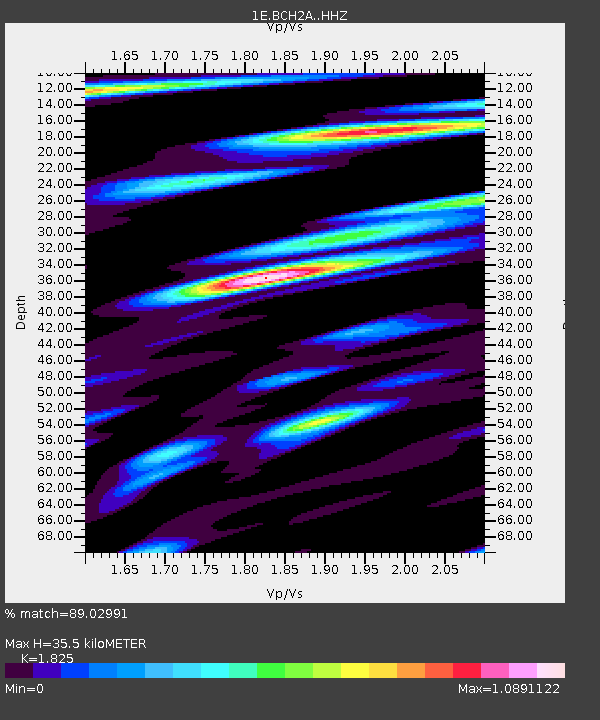
| Estimated Moho Depth: |
35.5 km |
| Estimated Crust Vp/Vs: |
1.83 |
| Assumed Crust Vp: |
6.303 km/s |
| Estimated Crust Vs: |
3.453 km/s |
| Estimated Crust Poisson's Ratio: |
0.29 |
|
| Radial Match: |
89.02991 % |
| Radial Bump: |
400 |
| Transverse Match: |
76.422104 % |
| Transverse Bump: |
400 |
| SOD ConfigId: |
26694651 |
| Insert Time: |
2022-02-04 16:09:18.348 +0000 |
| GWidth: |
2.5 |
| Max Bumps: |
400 |
| Tol: |
0.001 |
|

Signal To Noise
| Channel | StoN | STA | LTA |
| 1E:BCH2A: :HHZ:20220121T16:19:28.389992Z | 10.175072 | 3.105859E-6 | 3.0524197E-7 |
| 1E:BCH2A: :HHN:20220121T16:19:28.389992Z | 1.3016152 | 5.7114914E-7 | 4.3880027E-7 |
| 1E:BCH2A: :HHE:20220121T16:19:28.389992Z | 1.6347644 | 4.645353E-7 | 2.841604E-7 |
| Arrivals |
| Ps | 4.8 SECOND |
| PpPs | 15 SECOND |
| PsPs/PpSs | 20 SECOND |


