You are here: Home > Network List > 1E - GSC-BCOGC Induced Seismicity Study Stations List
> Station MONT5 Z > Earthquake Result Viewer
MONT5 Z - Earthquake Result Viewer
| Earthquake location: |
Shikoku, Japan |
| Earthquake latitude/longitude: |
32.8/132.0 |
| Earthquake time(UTC): |
2022/01/21 (021) 16:08:37 GMT |
| Earthquake Depth: |
42 km |
| Earthquake Magnitude: |
6.3 Mww |
| Earthquake Catalog/Contributor: |
NEIC PDE/us |
|
| Network: |
1E GSC-BCOGC Induced Seismicity Study |
| Station: |
MONT5 Z |
| Lat/Lon: |
57.03 N/122.34 W |
| Elevation: |
1097 m |
|
| Distance: |
70.9 deg |
| Az: |
33.864 deg |
| Baz: |
300.843 deg |
| Ray Param: |
0.05459248 |
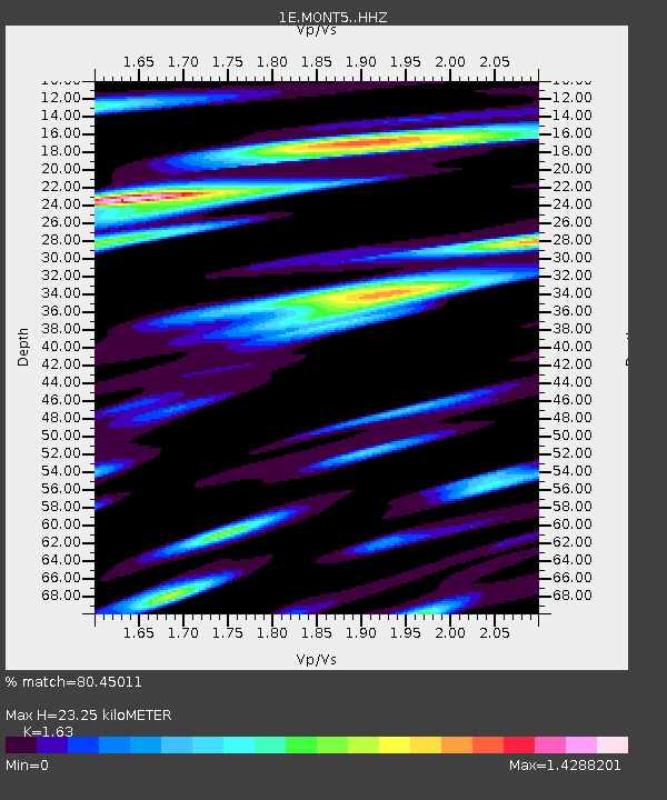
| Estimated Moho Depth: |
23.25 km |
| Estimated Crust Vp/Vs: |
1.63 |
| Assumed Crust Vp: |
6.232 km/s |
| Estimated Crust Vs: |
3.823 km/s |
| Estimated Crust Poisson's Ratio: |
0.20 |
|
| Radial Match: |
80.45011 % |
| Radial Bump: |
400 |
| Transverse Match: |
75.117546 % |
| Transverse Bump: |
400 |
| SOD ConfigId: |
26694651 |
| Insert Time: |
2022-02-04 16:09:23.702 +0000 |
| GWidth: |
2.5 |
| Max Bumps: |
400 |
| Tol: |
0.001 |
|

Signal To Noise
| Channel | StoN | STA | LTA |
| 1E:MONT5: :HHZ:20220121T16:19:19.369972Z | 4.1071415 | 1.6590504E-6 | 4.0394286E-7 |
| 1E:MONT5: :HHN:20220121T16:19:19.369972Z | 1.6757047 | 5.07481E-7 | 3.0284633E-7 |
| 1E:MONT5: :HHE:20220121T16:19:19.369972Z | 2.058704 | 8.282125E-7 | 4.02298E-7 |
| Arrivals |
| Ps | 2.4 SECOND |
| PpPs | 9.5 SECOND |
| PsPs/PpSs | 12 SECOND |


