You are here: Home > Network List > 1E - GSC-BCOGC Induced Seismicity Study Stations List
> Station MONT8 Z > Earthquake Result Viewer
MONT8 Z - Earthquake Result Viewer
| Earthquake location: |
Shikoku, Japan |
| Earthquake latitude/longitude: |
32.8/132.0 |
| Earthquake time(UTC): |
2022/01/21 (021) 16:08:37 GMT |
| Earthquake Depth: |
42 km |
| Earthquake Magnitude: |
6.3 Mww |
| Earthquake Catalog/Contributor: |
NEIC PDE/us |
|
| Network: |
1E GSC-BCOGC Induced Seismicity Study |
| Station: |
MONT8 Z |
| Lat/Lon: |
56.07 N/120.78 W |
| Elevation: |
695 m |
|
| Distance: |
72.2 deg |
| Az: |
34.252 deg |
| Baz: |
302.264 deg |
| Ray Param: |
0.053776853 |
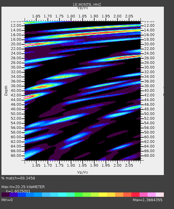
| Estimated Moho Depth: |
20.25 km |
| Estimated Crust Vp/Vs: |
1.60 |
| Assumed Crust Vp: |
6.291 km/s |
| Estimated Crust Vs: |
3.926 km/s |
| Estimated Crust Poisson's Ratio: |
0.18 |
|
| Radial Match: |
88.3456 % |
| Radial Bump: |
400 |
| Transverse Match: |
81.94786 % |
| Transverse Bump: |
400 |
| SOD ConfigId: |
26694651 |
| Insert Time: |
2022-02-04 16:09:27.225 +0000 |
| GWidth: |
2.5 |
| Max Bumps: |
400 |
| Tol: |
0.001 |
|

Signal To Noise
| Channel | StoN | STA | LTA |
| 1E:MONT8: :HHZ:20220121T16:19:26.809975Z | 8.527795 | 2.3468397E-6 | 2.751989E-7 |
| 1E:MONT8: :HHN:20220121T16:19:26.809975Z | 4.5852566 | 9.3199725E-7 | 2.0325957E-7 |
| 1E:MONT8: :HHE:20220121T16:19:26.809975Z | 3.3871987 | 6.6911815E-7 | 1.9754323E-7 |
| Arrivals |
| Ps | 2.0 SECOND |
| PpPs | 8.1 SECOND |
| PsPs/PpSs | 10 SECOND |


