You are here: Home > Network List > AV - Alaska Volcano Observatory Stations List
> Station AMKA Regional Station, Amchitka Island, Alaska > Earthquake Result Viewer
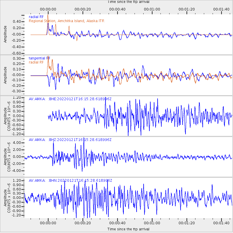
AMKA Regional Station, Amchitka Island, Alaska - Earthquake Result Viewer
*The percent match for this event was below the threshold and hence no stack was calculated.
| Earthquake location: |
Shikoku, Japan |
| Earthquake latitude/longitude: |
32.8/132.0 |
| Earthquake time(UTC): |
2022/01/21 (021) 16:08:37 GMT |
| Earthquake Depth: |
42 km |
| Earthquake Magnitude: |
6.3 Mww |
| Earthquake Catalog/Contributor: |
NEIC PDE/us |
|
| Network: |
AV Alaska Volcano Observatory |
| Station: |
AMKA Regional Station, Amchitka Island, Alaska |
| Lat/Lon: |
51.38 N/179.30 E |
| Elevation: |
116 m |
|
| Distance: |
38.9 deg |
| Az: |
47.121 deg |
| Baz: |
260.102 deg |
| Ray Param: |
$rayparam |
*The percent match for this event was below the threshold and hence was not used in the summary stack. |
|
| Radial Match: |
65.671616 % |
| Radial Bump: |
400 |
| Transverse Match: |
71.348885 % |
| Transverse Bump: |
400 |
| SOD ConfigId: |
26694651 |
| Insert Time: |
2022-02-04 16:14:37.506 +0000 |
| GWidth: |
2.5 |
| Max Bumps: |
400 |
| Tol: |
0.001 |
|
Signal To Noise
| Channel | StoN | STA | LTA |
| AV:AMKA: :BHZ:20220121T16:15:28.618996Z | 5.4658737 | 1.2151518E-6 | 2.2231612E-7 |
| AV:AMKA: :BHN:20220121T16:15:28.618996Z | 1.5898501 | 2.660911E-7 | 1.6736867E-7 |
| AV:AMKA: :BHE:20220121T16:15:28.618996Z | 2.4775076 | 4.2351132E-7 | 1.709425E-7 |
| Arrivals |
| Ps | |
| PpPs | |
| PsPs/PpSs | |


