You are here: Home > Network List > II - Global Seismograph Network (GSN - IRIS/IDA) Stations List
> Station WRAB Tennant Creek, NT, Australia > Earthquake Result Viewer
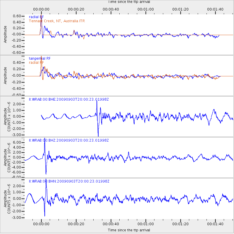
WRAB Tennant Creek, NT, Australia - Earthquake Result Viewer
*The percent match for this event was below the threshold and hence no stack was calculated.
| Earthquake location: |
Myanmar-India Border Region |
| Earthquake latitude/longitude: |
24.3/94.7 |
| Earthquake time(UTC): |
2009/09/03 (246) 19:51:08 GMT |
| Earthquake Depth: |
105 km |
| Earthquake Magnitude: |
5.7 MB, 5.9 MW, 5.8 MW |
| Earthquake Catalog/Contributor: |
WHDF/NEIC |
|
| Network: |
II Global Seismograph Network (GSN - IRIS/IDA) |
| Station: |
WRAB Tennant Creek, NT, Australia |
| Lat/Lon: |
19.93 S/134.36 E |
| Elevation: |
366 m |
|
| Distance: |
58.6 deg |
| Az: |
135.245 deg |
| Baz: |
316.947 deg |
| Ray Param: |
$rayparam |
*The percent match for this event was below the threshold and hence was not used in the summary stack. |
|
| Radial Match: |
76.61984 % |
| Radial Bump: |
400 |
| Transverse Match: |
80.01796 % |
| Transverse Bump: |
400 |
| SOD ConfigId: |
1 |
| Insert Time: |
2010-02-19 00:07:39.383 +0000 |
| GWidth: |
2.5 |
| Max Bumps: |
400 |
| Tol: |
0.001 |
|
Signal To Noise
| Channel | StoN | STA | LTA |
| II:WRAB:00:BHZ:20090903T20:00:23.01998Z | 3.988567 | 2.500056E-6 | 6.268056E-7 |
| II:WRAB:00:BHN:20090903T20:00:23.01998Z | 1.7617885 | 1.0289581E-6 | 5.840418E-7 |
| II:WRAB:00:BHE:20090903T20:00:23.01998Z | 4.721807 | 1.116188E-6 | 2.3639E-7 |
| Arrivals |
| Ps | |
| PpPs | |
| PsPs/PpSs | |


