You are here: Home > Network List > CC - Cascade Chain Volcano Monitoring Stations List
> Station CRBN Carbon River Ranger Station > Earthquake Result Viewer
CRBN Carbon River Ranger Station - Earthquake Result Viewer
| Earthquake location: |
Shikoku, Japan |
| Earthquake latitude/longitude: |
32.8/132.0 |
| Earthquake time(UTC): |
2022/01/21 (021) 16:08:37 GMT |
| Earthquake Depth: |
42 km |
| Earthquake Magnitude: |
6.3 Mww |
| Earthquake Catalog/Contributor: |
NEIC PDE/us |
|
| Network: |
CC Cascade Chain Volcano Monitoring |
| Station: |
CRBN Carbon River Ranger Station |
| Lat/Lon: |
46.99 N/121.96 W |
| Elevation: |
500 m |
|
| Distance: |
76.5 deg |
| Az: |
42.595 deg |
| Baz: |
303.596 deg |
| Ray Param: |
0.050898373 |
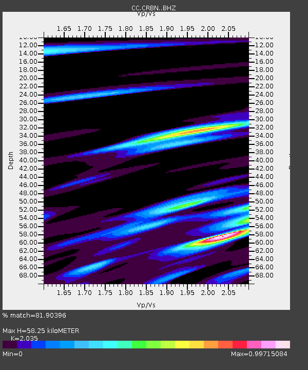
| Estimated Moho Depth: |
58.25 km |
| Estimated Crust Vp/Vs: |
2.04 |
| Assumed Crust Vp: |
6.597 km/s |
| Estimated Crust Vs: |
3.242 km/s |
| Estimated Crust Poisson's Ratio: |
0.34 |
|
| Radial Match: |
81.90396 % |
| Radial Bump: |
400 |
| Transverse Match: |
68.76983 % |
| Transverse Bump: |
400 |
| SOD ConfigId: |
26694651 |
| Insert Time: |
2022-02-04 16:18:08.162 +0000 |
| GWidth: |
2.5 |
| Max Bumps: |
400 |
| Tol: |
0.001 |
|

Signal To Noise
| Channel | StoN | STA | LTA |
| CC:CRBN: :BHZ:20220121T16:19:51.920021Z | 6.8608913 | 1.1698589E-6 | 1.7051121E-7 |
| CC:CRBN: :BHN:20220121T16:19:51.920021Z | 1.0182105 | 2.0925178E-7 | 2.0550932E-7 |
| CC:CRBN: :BHE:20220121T16:19:51.920021Z | 1.988209 | 4.1318182E-7 | 2.0781609E-7 |
| Arrivals |
| Ps | 9.4 SECOND |
| PpPs | 26 SECOND |
| PsPs/PpSs | 35 SECOND |


