You are here: Home > Network List > CC - Cascade Chain Volcano Monitoring Stations List
> Station SIFT Swift Creek > Earthquake Result Viewer
SIFT Swift Creek - Earthquake Result Viewer
| Earthquake location: |
Shikoku, Japan |
| Earthquake latitude/longitude: |
32.8/132.0 |
| Earthquake time(UTC): |
2022/01/21 (021) 16:08:37 GMT |
| Earthquake Depth: |
42 km |
| Earthquake Magnitude: |
6.3 Mww |
| Earthquake Catalog/Contributor: |
NEIC PDE/us |
|
| Network: |
CC Cascade Chain Volcano Monitoring |
| Station: |
SIFT Swift Creek |
| Lat/Lon: |
46.87 N/121.95 W |
| Elevation: |
732 m |
|
| Distance: |
76.6 deg |
| Az: |
42.696 deg |
| Baz: |
303.625 deg |
| Ray Param: |
0.050849438 |
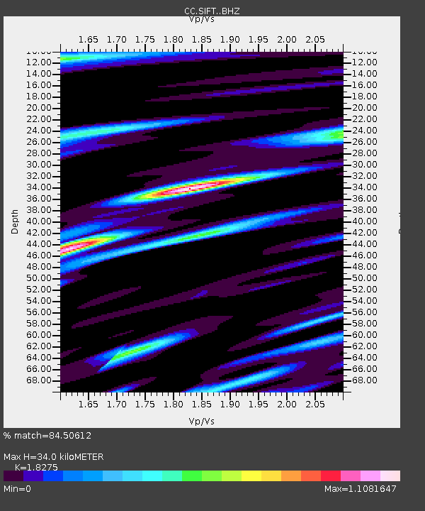
| Estimated Moho Depth: |
34.0 km |
| Estimated Crust Vp/Vs: |
1.83 |
| Assumed Crust Vp: |
6.597 km/s |
| Estimated Crust Vs: |
3.61 km/s |
| Estimated Crust Poisson's Ratio: |
0.29 |
|
| Radial Match: |
84.50612 % |
| Radial Bump: |
400 |
| Transverse Match: |
71.72576 % |
| Transverse Bump: |
400 |
| SOD ConfigId: |
26694651 |
| Insert Time: |
2022-02-04 16:18:43.756 +0000 |
| GWidth: |
2.5 |
| Max Bumps: |
400 |
| Tol: |
0.001 |
|

Signal To Noise
| Channel | StoN | STA | LTA |
| CC:SIFT: :BHZ:20220121T16:19:52.340004Z | 3.3673642 | 8.999872E-7 | 2.6726755E-7 |
| CC:SIFT: :BHN:20220121T16:19:52.340004Z | 1.7668742 | 2.1546431E-7 | 1.219466E-7 |
| CC:SIFT: :BHE:20220121T16:19:52.340004Z | 2.051854 | 5.7591444E-7 | 2.8068004E-7 |
| Arrivals |
| Ps | 4.4 SECOND |
| PpPs | 14 SECOND |
| PsPs/PpSs | 19 SECOND |


