You are here: Home > Network List > CI - Caltech Regional Seismic Network Stations List
> Station MPP McPhearson Peak > Earthquake Result Viewer
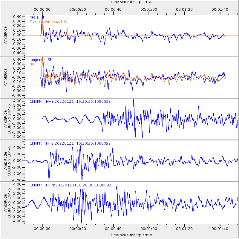
MPP McPhearson Peak - Earthquake Result Viewer
*The percent match for this event was below the threshold and hence no stack was calculated.
| Earthquake location: |
Shikoku, Japan |
| Earthquake latitude/longitude: |
32.8/132.0 |
| Earthquake time(UTC): |
2022/01/21 (021) 16:08:37 GMT |
| Earthquake Depth: |
42 km |
| Earthquake Magnitude: |
6.3 Mww |
| Earthquake Catalog/Contributor: |
NEIC PDE/us |
|
| Network: |
CI Caltech Regional Seismic Network |
| Station: |
MPP McPhearson Peak |
| Lat/Lon: |
34.89 N/119.81 W |
| Elevation: |
1739 m |
|
| Distance: |
84.8 deg |
| Az: |
51.668 deg |
| Baz: |
306.489 deg |
| Ray Param: |
$rayparam |
*The percent match for this event was below the threshold and hence was not used in the summary stack. |
|
| Radial Match: |
80.38988 % |
| Radial Bump: |
400 |
| Transverse Match: |
72.26298 % |
| Transverse Bump: |
400 |
| SOD ConfigId: |
26694651 |
| Insert Time: |
2022-02-04 16:20:33.988 +0000 |
| GWidth: |
2.5 |
| Max Bumps: |
400 |
| Tol: |
0.001 |
|
Signal To Noise
| Channel | StoN | STA | LTA |
| CI:MPP: :HHZ:20220121T16:20:36.108009Z | 8.102485 | 1.8337395E-6 | 2.2631816E-7 |
| CI:MPP: :HHN:20220121T16:20:36.108009Z | 2.4911132 | 7.545209E-7 | 3.0288504E-7 |
| CI:MPP: :HHE:20220121T16:20:36.108009Z | 2.1514323 | 9.4990276E-7 | 4.4152114E-7 |
| Arrivals |
| Ps | |
| PpPs | |
| PsPs/PpSs | |


