You are here: Home > Network List > GS - US Geological Survey Networks Stations List
> Station VEA2 VEA1 > Earthquake Result Viewer
VEA2 VEA1 - Earthquake Result Viewer
| Earthquake location: |
Shikoku, Japan |
| Earthquake latitude/longitude: |
32.8/132.0 |
| Earthquake time(UTC): |
2022/01/21 (021) 16:08:37 GMT |
| Earthquake Depth: |
42 km |
| Earthquake Magnitude: |
6.3 Mww |
| Earthquake Catalog/Contributor: |
NEIC PDE/us |
|
| Network: |
GS US Geological Survey Networks |
| Station: |
VEA2 VEA1 |
| Lat/Lon: |
34.94 N/106.46 W |
| Elevation: |
1844 m |
|
| Distance: |
93.1 deg |
| Az: |
44.547 deg |
| Baz: |
313.991 deg |
| Ray Param: |
0.041314926 |
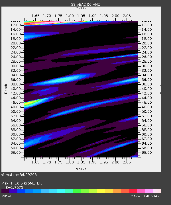
| Estimated Moho Depth: |
10.5 km |
| Estimated Crust Vp/Vs: |
1.76 |
| Assumed Crust Vp: |
6.502 km/s |
| Estimated Crust Vs: |
3.699 km/s |
| Estimated Crust Poisson's Ratio: |
0.26 |
|
| Radial Match: |
86.09303 % |
| Radial Bump: |
306 |
| Transverse Match: |
70.24781 % |
| Transverse Bump: |
395 |
| SOD ConfigId: |
26694651 |
| Insert Time: |
2022-02-04 16:25:59.062 +0000 |
| GWidth: |
2.5 |
| Max Bumps: |
400 |
| Tol: |
0.001 |
|

Signal To Noise
| Channel | StoN | STA | LTA |
| GS:VEA2:00:HHZ:20220121T16:21:15.618996Z | 6.8698387 | 5.554141E-7 | 8.0848196E-8 |
| GS:VEA2:00:HH1:20220121T16:21:15.618996Z | 1.0101902 | 7.5308094E-8 | 7.454843E-8 |
| GS:VEA2:00:HH2:20220121T16:21:15.618996Z | 1.3678119 | 1.1643329E-7 | 8.512376E-8 |
| Arrivals |
| Ps | 1.2 SECOND |
| PpPs | 4.4 SECOND |
| PsPs/PpSs | 5.6 SECOND |


