You are here: Home > Network List > NN - Western Great Basin/Eastern Sierra Nevada Stations List
> Station MCA06 Monte Cristo ASL 06 > Earthquake Result Viewer
MCA06 Monte Cristo ASL 06 - Earthquake Result Viewer
| Earthquake location: |
Shikoku, Japan |
| Earthquake latitude/longitude: |
32.8/132.0 |
| Earthquake time(UTC): |
2022/01/21 (021) 16:08:37 GMT |
| Earthquake Depth: |
42 km |
| Earthquake Magnitude: |
6.3 Mww |
| Earthquake Catalog/Contributor: |
NEIC PDE/us |
|
| Network: |
NN Western Great Basin/Eastern Sierra Nevada |
| Station: |
MCA06 Monte Cristo ASL 06 |
| Lat/Lon: |
38.01 N/117.88 W |
| Elevation: |
1462 m |
|
| Distance: |
84.2 deg |
| Az: |
48.226 deg |
| Baz: |
307.3 deg |
| Ray Param: |
0.045618437 |
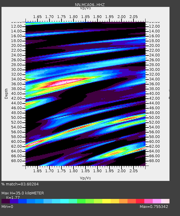
| Estimated Moho Depth: |
35.0 km |
| Estimated Crust Vp/Vs: |
1.77 |
| Assumed Crust Vp: |
6.276 km/s |
| Estimated Crust Vs: |
3.546 km/s |
| Estimated Crust Poisson's Ratio: |
0.27 |
|
| Radial Match: |
83.68284 % |
| Radial Bump: |
400 |
| Transverse Match: |
75.81297 % |
| Transverse Bump: |
400 |
| SOD ConfigId: |
26694651 |
| Insert Time: |
2022-02-04 16:30:20.570 +0000 |
| GWidth: |
2.5 |
| Max Bumps: |
400 |
| Tol: |
0.001 |
|

Signal To Noise
| Channel | StoN | STA | LTA |
| NN:MCA06: :HHZ:20220121T16:20:32.970009Z | 12.286955 | 1.279613E-6 | 1.0414403E-7 |
| NN:MCA06: :HHN:20220121T16:20:32.970009Z | 1.7914869 | 5.167597E-7 | 2.8845295E-7 |
| NN:MCA06: :HHE:20220121T16:20:32.970009Z | 4.4257483 | 4.1116468E-7 | 9.290285E-8 |
| Arrivals |
| Ps | 4.4 SECOND |
| PpPs | 15 SECOND |
| PsPs/PpSs | 19 SECOND |


