You are here: Home > Network List > NN - Western Great Basin/Eastern Sierra Nevada Stations List
> Station ZPR Zephyr Cove, Lake Tahoe, Nevada > Earthquake Result Viewer
ZPR Zephyr Cove, Lake Tahoe, Nevada - Earthquake Result Viewer
| Earthquake location: |
Shikoku, Japan |
| Earthquake latitude/longitude: |
32.8/132.0 |
| Earthquake time(UTC): |
2022/01/21 (021) 16:08:37 GMT |
| Earthquake Depth: |
42 km |
| Earthquake Magnitude: |
6.3 Mww |
| Earthquake Catalog/Contributor: |
NEIC PDE/us |
|
| Network: |
NN Western Great Basin/Eastern Sierra Nevada |
| Station: |
ZPR Zephyr Cove, Lake Tahoe, Nevada |
| Lat/Lon: |
39.01 N/119.94 W |
| Elevation: |
2001 m |
|
| Distance: |
82.3 deg |
| Az: |
48.387 deg |
| Baz: |
306.044 deg |
| Ray Param: |
0.04694523 |
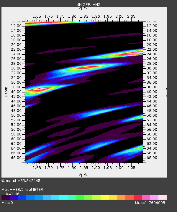
| Estimated Moho Depth: |
38.5 km |
| Estimated Crust Vp/Vs: |
1.66 |
| Assumed Crust Vp: |
6.279 km/s |
| Estimated Crust Vs: |
3.782 km/s |
| Estimated Crust Poisson's Ratio: |
0.22 |
|
| Radial Match: |
83.842445 % |
| Radial Bump: |
400 |
| Transverse Match: |
97.703384 % |
| Transverse Bump: |
195 |
| SOD ConfigId: |
26694651 |
| Insert Time: |
2022-02-04 16:30:53.263 +0000 |
| GWidth: |
2.5 |
| Max Bumps: |
400 |
| Tol: |
0.001 |
|

Signal To Noise
| Channel | StoN | STA | LTA |
| NN:ZPR: :HHZ:20220121T16:20:23.248024Z | 7.4770803 | 7.6741196E-7 | 1.0263524E-7 |
| NN:ZPR: :HHN:20220121T16:20:23.248024Z | 2.2746484 | 3.3110533E-7 | 1.4556329E-7 |
| NN:ZPR: :HHE:20220121T16:20:23.248024Z | 4.222152 | 6.237117E-7 | 1.4772365E-7 |
| Arrivals |
| Ps | 4.2 SECOND |
| PpPs | 16 SECOND |
| PsPs/PpSs | 20 SECOND |


