You are here: Home > Network List > PY - PFO Array Stations List
> Station BPH10 Pinon Flat Observatory, CA, USA > Earthquake Result Viewer
BPH10 Pinon Flat Observatory, CA, USA - Earthquake Result Viewer
| Earthquake location: |
Shikoku, Japan |
| Earthquake latitude/longitude: |
32.8/132.0 |
| Earthquake time(UTC): |
2022/01/21 (021) 16:08:37 GMT |
| Earthquake Depth: |
42 km |
| Earthquake Magnitude: |
6.3 Mww |
| Earthquake Catalog/Contributor: |
NEIC PDE/us |
|
| Network: |
PY PFO Array |
| Station: |
BPH10 Pinon Flat Observatory, CA, USA |
| Lat/Lon: |
33.61 N/116.45 W |
| Elevation: |
1300 m |
|
| Distance: |
87.8 deg |
| Az: |
50.986 deg |
| Baz: |
308.328 deg |
| Ray Param: |
0.04302555 |
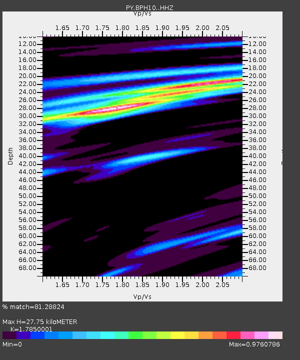
| Estimated Moho Depth: |
27.75 km |
| Estimated Crust Vp/Vs: |
1.79 |
| Assumed Crust Vp: |
6.264 km/s |
| Estimated Crust Vs: |
3.509 km/s |
| Estimated Crust Poisson's Ratio: |
0.27 |
|
| Radial Match: |
81.28824 % |
| Radial Bump: |
383 |
| Transverse Match: |
76.80142 % |
| Transverse Bump: |
397 |
| SOD ConfigId: |
26694651 |
| Insert Time: |
2022-02-04 16:33:52.396 +0000 |
| GWidth: |
2.5 |
| Max Bumps: |
400 |
| Tol: |
0.001 |
|

Signal To Noise
| Channel | StoN | STA | LTA |
| PY:BPH10: :HHZ:20220121T16:20:50.710976Z | 4.005628 | 8.210363E-7 | 2.0497066E-7 |
| PY:BPH10: :HHN:20220121T16:20:50.710976Z | 0.84570116 | 1.6524139E-7 | 1.9538982E-7 |
| PY:BPH10: :HHE:20220121T16:20:50.710976Z | 1.9233023 | 2.1686948E-7 | 1.1275891E-7 |
| Arrivals |
| Ps | 3.6 SECOND |
| PpPs | 12 SECOND |
| PsPs/PpSs | 16 SECOND |


