You are here: Home > Network List > XE05 - Sierra Nevada EarthScope Project- EarthScope Flex Array Stations List
> Station SNP52 SNP52 > Earthquake Result Viewer
SNP52 SNP52 - Earthquake Result Viewer
| Earthquake location: |
New Ireland Region, P.N.G. |
| Earthquake latitude/longitude: |
-4.5/153.5 |
| Earthquake time(UTC): |
2005/09/09 (252) 07:26:43 GMT |
| Earthquake Depth: |
90 km |
| Earthquake Magnitude: |
6.3 MB, 7.7 MW, 7.5 MW |
| Earthquake Catalog/Contributor: |
WHDF/NEIC |
|
| Network: |
XE Sierra Nevada EarthScope Project- EarthScope Flex Array |
| Station: |
SNP52 SNP52 |
| Lat/Lon: |
37.34 N/119.81 W |
| Elevation: |
341 m |
|
| Distance: |
90.1 deg |
| Az: |
52.719 deg |
| Baz: |
264.422 deg |
| Ray Param: |
0.04167968 |
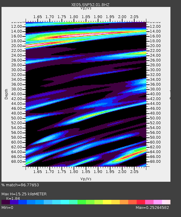
| Estimated Moho Depth: |
15.25 km |
| Estimated Crust Vp/Vs: |
1.84 |
| Assumed Crust Vp: |
6.291 km/s |
| Estimated Crust Vs: |
3.419 km/s |
| Estimated Crust Poisson's Ratio: |
0.29 |
|
| Radial Match: |
96.77653 % |
| Radial Bump: |
345 |
| Transverse Match: |
89.62086 % |
| Transverse Bump: |
400 |
| SOD ConfigId: |
268666 |
| Insert Time: |
2010-03-09 16:00:18.957 +0000 |
| GWidth: |
2.5 |
| Max Bumps: |
400 |
| Tol: |
0.001 |
|

Signal To Noise
| Channel | StoN | STA | LTA |
| XE:SNP52:01:BHZ:20050909T07:39:02.464009Z | 10.244391 | 1.0891902E-6 | 1.0632063E-7 |
| XE:SNP52:01:BHN:20050909T07:39:02.464009Z | 1.3484602 | 6.6484354E-8 | 4.9303903E-8 |
| XE:SNP52:01:BHE:20050909T07:39:02.464009Z | 8.607744 | 3.5735744E-7 | 4.1515804E-8 |
| Arrivals |
| Ps | 2.1 SECOND |
| PpPs | 6.8 SECOND |
| PsPs/PpSs | 8.8 SECOND |


