You are here: Home > Network List > US - United States National Seismic Network Stations List
> Station DGMT Dagmar, Montana, USA > Earthquake Result Viewer
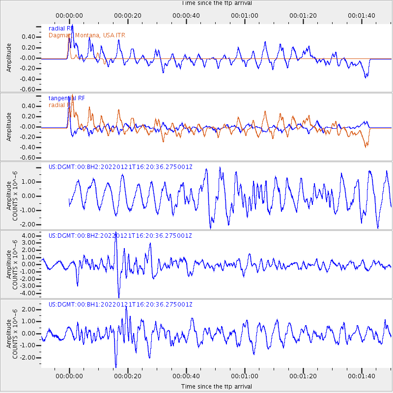
DGMT Dagmar, Montana, USA - Earthquake Result Viewer
*The percent match for this event was below the threshold and hence no stack was calculated.
| Earthquake location: |
Shikoku, Japan |
| Earthquake latitude/longitude: |
32.8/132.0 |
| Earthquake time(UTC): |
2022/01/21 (021) 16:08:37 GMT |
| Earthquake Depth: |
42 km |
| Earthquake Magnitude: |
6.3 Mww |
| Earthquake Catalog/Contributor: |
NEIC PDE/us |
|
| Network: |
US United States National Seismic Network |
| Station: |
DGMT Dagmar, Montana, USA |
| Lat/Lon: |
48.47 N/104.20 W |
| Elevation: |
0.0 m |
|
| Distance: |
84.8 deg |
| Az: |
33.747 deg |
| Baz: |
315.307 deg |
| Ray Param: |
$rayparam |
*The percent match for this event was below the threshold and hence was not used in the summary stack. |
|
| Radial Match: |
72.78911 % |
| Radial Bump: |
400 |
| Transverse Match: |
74.36916 % |
| Transverse Bump: |
338 |
| SOD ConfigId: |
26694651 |
| Insert Time: |
2022-02-04 16:37:48.346 +0000 |
| GWidth: |
2.5 |
| Max Bumps: |
400 |
| Tol: |
0.001 |
|
Signal To Noise
| Channel | StoN | STA | LTA |
| US:DGMT:00:BHZ:20220121T16:20:36.275001Z | 2.6727366 | 9.272741E-7 | 3.4693804E-7 |
| US:DGMT:00:BH1:20220121T16:20:36.275001Z | 1.2672775 | 4.995233E-7 | 3.9417046E-7 |
| US:DGMT:00:BH2:20220121T16:20:36.275001Z | 0.9314794 | 6.7221595E-7 | 7.2166483E-7 |
| Arrivals |
| Ps | |
| PpPs | |
| PsPs/PpSs | |


