You are here: Home > Network List > MM - Myanmar National Seismic Network Stations List
> Station TGI Taung Gyi, Myanmar > Earthquake Result Viewer
TGI Taung Gyi, Myanmar - Earthquake Result Viewer
| Earthquake location: |
Talaud Islands, Indonesia |
| Earthquake latitude/longitude: |
3.7/126.7 |
| Earthquake time(UTC): |
2022/01/22 (022) 02:26:13 GMT |
| Earthquake Depth: |
24 km |
| Earthquake Magnitude: |
6.0 mww |
| Earthquake Catalog/Contributor: |
NEIC PDE/us |
|
| Network: |
MM Myanmar National Seismic Network |
| Station: |
TGI Taung Gyi, Myanmar |
| Lat/Lon: |
20.77 N/97.03 E |
| Elevation: |
1458 m |
|
| Distance: |
33.5 deg |
| Az: |
302.928 deg |
| Baz: |
116.479 deg |
| Ray Param: |
0.07818209 |
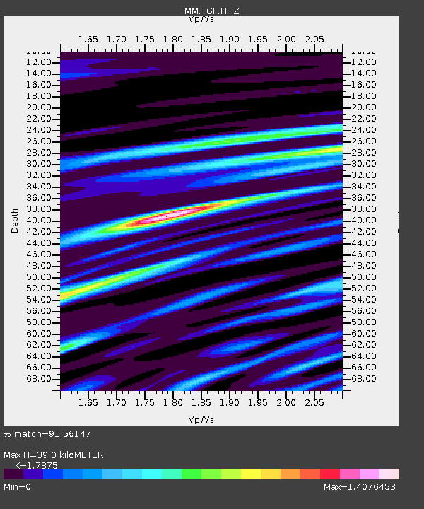
| Estimated Moho Depth: |
39.0 km |
| Estimated Crust Vp/Vs: |
1.79 |
| Assumed Crust Vp: |
6.316 km/s |
| Estimated Crust Vs: |
3.533 km/s |
| Estimated Crust Poisson's Ratio: |
0.27 |
|
| Radial Match: |
91.56147 % |
| Radial Bump: |
301 |
| Transverse Match: |
66.76686 % |
| Transverse Bump: |
400 |
| SOD ConfigId: |
26694651 |
| Insert Time: |
2022-02-05 02:37:59.185 +0000 |
| GWidth: |
2.5 |
| Max Bumps: |
400 |
| Tol: |
0.001 |
|

Signal To Noise
| Channel | StoN | STA | LTA |
| MM:TGI: :HHZ:20220122T02:32:20.079989Z | 11.899021 | 1.0063364E-6 | 8.4573045E-8 |
| MM:TGI: :HHN:20220122T02:32:20.079989Z | 5.6275434 | 2.8610654E-7 | 5.08404E-8 |
| MM:TGI: :HHE:20220122T02:32:20.079989Z | 6.064665 | 5.599962E-7 | 9.233753E-8 |
| Arrivals |
| Ps | 5.2 SECOND |
| PpPs | 16 SECOND |
| PsPs/PpSs | 21 SECOND |


