You are here: Home > Network List > CI - Caltech Regional Seismic Network Stations List
> Station FMP Fort MacArthur Park, Pt. Fermin San Pedro, CA, USA > Earthquake Result Viewer
FMP Fort MacArthur Park, Pt. Fermin San Pedro, CA, USA - Earthquake Result Viewer

| Earthquake location: |
Fox Islands, Aleutian Islands |
| Earthquake latitude/longitude: |
53.1/-166.6 |
| Earthquake time(UTC): |
2022/01/22 (022) 05:17:03 GMT |
| Earthquake Depth: |
3.0 km |
| Earthquake Magnitude: |
6.3 Mi |
| Earthquake Catalog/Contributor: |
NEIC PDE/at |
|
| Network: |
CI Caltech Regional Seismic Network |
| Station: |
FMP Fort MacArthur Park, Pt. Fermin San Pedro, CA, USA |
| Lat/Lon: |
33.71 N/118.29 W |
| Elevation: |
89 m |
|
| Distance: |
39.2 deg |
| Az: |
99.957 deg |
| Baz: |
314.548 deg |
| Ray Param: |
0.075173326 |
| Estimated Moho Depth: |
24.75 km |
| Estimated Crust Vp/Vs: |
1.61 |
| Assumed Crust Vp: |
6.048 km/s |
| Estimated Crust Vs: |
3.768 km/s |
| Estimated Crust Poisson's Ratio: |
0.18 |
|
| Radial Match: |
84.364365 % |
| Radial Bump: |
400 |
| Transverse Match: |
62.877644 % |
| Transverse Bump: |
400 |
| SOD ConfigId: |
26694651 |
| Insert Time: |
2022-02-05 05:22:45.268 +0000 |
| GWidth: |
2.5 |
| Max Bumps: |
400 |
| Tol: |
0.001 |
|
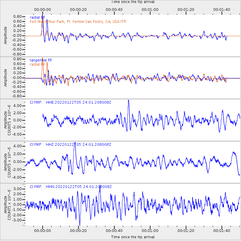
Signal To Noise
| Channel | StoN | STA | LTA |
| CI:FMP: :HHZ:20220122T05:24:01.208008Z | 1.6894686 | 7.569428E-7 | 4.4803602E-7 |
| CI:FMP: :HHN:20220122T05:24:01.208008Z | 1.0022533 | 5.1042923E-7 | 5.092817E-7 |
| CI:FMP: :HHE:20220122T05:24:01.208008Z | 0.7032601 | 5.696001E-7 | 8.0994226E-7 |
| Arrivals |
| Ps | 2.7 SECOND |
| PpPs | 9.9 SECOND |
| PsPs/PpSs | 13 SECOND |


