You are here: Home > Network List > II - Global Seismograph Network (GSN - IRIS/IDA) Stations List
> Station XPFO Pinon Flat, California, USA > Earthquake Result Viewer
XPFO Pinon Flat, California, USA - Earthquake Result Viewer
| Earthquake location: |
Fox Islands, Aleutian Islands |
| Earthquake latitude/longitude: |
53.1/-166.6 |
| Earthquake time(UTC): |
2022/01/22 (022) 05:17:03 GMT |
| Earthquake Depth: |
3.0 km |
| Earthquake Magnitude: |
6.3 Mi |
| Earthquake Catalog/Contributor: |
NEIC PDE/at |
|
| Network: |
II Global Seismograph Network (GSN - IRIS/IDA) |
| Station: |
XPFO Pinon Flat, California, USA |
| Lat/Lon: |
33.61 N/116.46 W |
| Elevation: |
1280 m |
|
| Distance: |
40.3 deg |
| Az: |
98.391 deg |
| Baz: |
314.359 deg |
| Ray Param: |
0.07447444 |
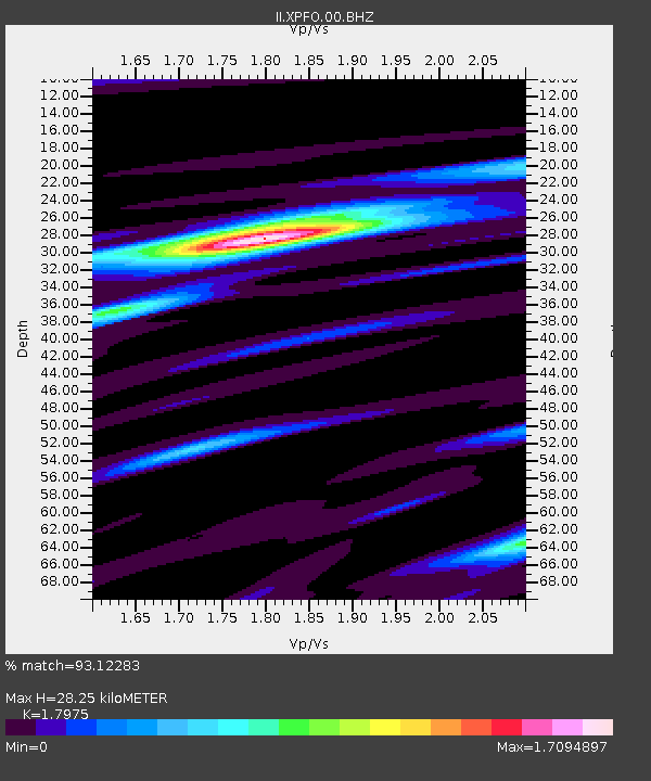
| Estimated Moho Depth: |
28.25 km |
| Estimated Crust Vp/Vs: |
1.80 |
| Assumed Crust Vp: |
6.264 km/s |
| Estimated Crust Vs: |
3.485 km/s |
| Estimated Crust Poisson's Ratio: |
0.28 |
|
| Radial Match: |
93.12283 % |
| Radial Bump: |
217 |
| Transverse Match: |
62.229225 % |
| Transverse Bump: |
400 |
| SOD ConfigId: |
26694651 |
| Insert Time: |
2022-02-05 05:30:54.809 +0000 |
| GWidth: |
2.5 |
| Max Bumps: |
400 |
| Tol: |
0.001 |
|

Signal To Noise
| Channel | StoN | STA | LTA |
| II:XPFO:00:BHZ:20220122T05:24:10.894012Z | 1.8715822 | 4.6799082E-7 | 2.5005093E-7 |
| II:XPFO:00:BH1:20220122T05:24:10.894012Z | 2.146898 | 4.1098386E-7 | 1.9143148E-7 |
| II:XPFO:00:BH2:20220122T05:24:10.894012Z | 0.6479944 | 1.3052527E-7 | 2.0142964E-7 |
| Arrivals |
| Ps | 3.8 SECOND |
| PpPs | 12 SECOND |
| PsPs/PpSs | 16 SECOND |


