You are here: Home > Network List > XE05 - Sierra Nevada EarthScope Project- EarthScope Flex Array Stations List
> Station SNP53 SNP53 > Earthquake Result Viewer
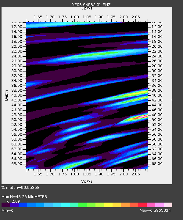
SNP53 SNP53 - Earthquake Result Viewer
| Earthquake location: |
New Ireland Region, P.N.G. |
| Earthquake latitude/longitude: |
-4.5/153.5 |
| Earthquake time(UTC): |
2005/09/09 (252) 07:26:43 GMT |
| Earthquake Depth: |
90 km |
| Earthquake Magnitude: |
6.3 MB, 7.7 MW, 7.5 MW |
| Earthquake Catalog/Contributor: |
WHDF/NEIC |
|
| Network: |
XE Sierra Nevada EarthScope Project- EarthScope Flex Array |
| Station: |
SNP53 SNP53 |
| Lat/Lon: |
37.51 N/119.67 W |
| Elevation: |
1459 m |
|
| Distance: |
90.2 deg |
| Az: |
52.559 deg |
| Baz: |
264.508 deg |
| Ray Param: |
0.0416706 |
| Estimated Moho Depth: |
48.25 km |
| Estimated Crust Vp/Vs: |
2.09 |
| Assumed Crust Vp: |
6.291 km/s |
| Estimated Crust Vs: |
3.01 km/s |
| Estimated Crust Poisson's Ratio: |
0.35 |
|
| Radial Match: |
96.95358 % |
| Radial Bump: |
361 |
| Transverse Match: |
84.44628 % |
| Transverse Bump: |
400 |
| SOD ConfigId: |
268666 |
| Insert Time: |
2010-03-09 16:04:17.734 +0000 |
| GWidth: |
2.5 |
| Max Bumps: |
400 |
| Tol: |
0.001 |
|

Signal To Noise
| Channel | StoN | STA | LTA |
| XE:SNP53:01:BHZ:20050909T07:39:03.065022Z | 10.941861 | 9.978329E-7 | 9.1194075E-8 |
| XE:SNP53:01:BHN:20050909T07:39:03.065022Z | 2.6986408 | 2.947045E-7 | 1.0920479E-7 |
| XE:SNP53:01:BHE:20050909T07:39:03.065022Z | 5.725359 | 4.4898425E-7 | 7.842028E-8 |
| Arrivals |
| Ps | 8.5 SECOND |
| PpPs | 23 SECOND |
| PsPs/PpSs | 32 SECOND |


