You are here: Home > Network List > XE05 - Sierra Nevada EarthScope Project- EarthScope Flex Array Stations List
> Station SNP53 SNP53 > Earthquake Result Viewer
SNP53 SNP53 - Earthquake Result Viewer
| Earthquake location: |
Chile-Bolivia Border Region |
| Earthquake latitude/longitude: |
-22.3/-67.9 |
| Earthquake time(UTC): |
2005/11/17 (321) 19:26:56 GMT |
| Earthquake Depth: |
163 km |
| Earthquake Magnitude: |
6.0 MB, 6.9 MW, 6.8 MW |
| Earthquake Catalog/Contributor: |
WHDF/NEIC |
|
| Network: |
XE Sierra Nevada EarthScope Project- EarthScope Flex Array |
| Station: |
SNP53 SNP53 |
| Lat/Lon: |
37.51 N/119.67 W |
| Elevation: |
1459 m |
|
| Distance: |
76.9 deg |
| Az: |
320.099 deg |
| Baz: |
131.671 deg |
| Ray Param: |
0.05027354 |
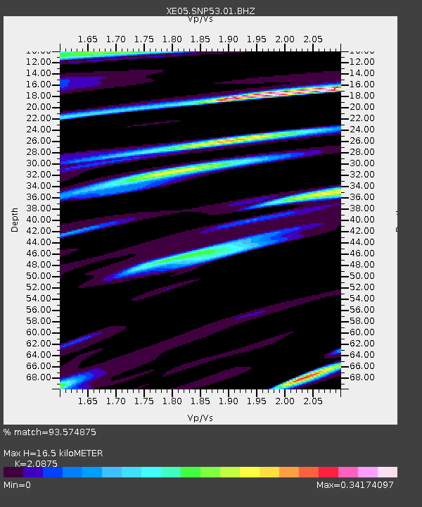
| Estimated Moho Depth: |
16.5 km |
| Estimated Crust Vp/Vs: |
2.09 |
| Assumed Crust Vp: |
6.291 km/s |
| Estimated Crust Vs: |
3.014 km/s |
| Estimated Crust Poisson's Ratio: |
0.35 |
|
| Radial Match: |
93.574875 % |
| Radial Bump: |
400 |
| Transverse Match: |
84.141685 % |
| Transverse Bump: |
400 |
| SOD ConfigId: |
268666 |
| Insert Time: |
2010-03-09 16:04:33.744 +0000 |
| GWidth: |
2.5 |
| Max Bumps: |
400 |
| Tol: |
0.001 |
|

Signal To Noise
| Channel | StoN | STA | LTA |
| XE:SNP53:01:BHZ:20051117T19:37:59.705024Z | 38.598133 | 5.7112256E-6 | 1.4796636E-7 |
| XE:SNP53:01:BHN:20051117T19:37:59.705024Z | 7.3457365 | 1.5972316E-6 | 2.1743656E-7 |
| XE:SNP53:01:BHE:20051117T19:37:59.705024Z | 10.116653 | 1.1019958E-6 | 1.08928894E-7 |
| Arrivals |
| Ps | 2.9 SECOND |
| PpPs | 7.9 SECOND |
| PsPs/PpSs | 11 SECOND |


