You are here: Home > Network List > MM - Myanmar National Seismic Network Stations List
> Station TGI Taung Gyi, Myanmar > Earthquake Result Viewer
TGI Taung Gyi, Myanmar - Earthquake Result Viewer
| Earthquake location: |
Fox Islands, Aleutian Islands |
| Earthquake latitude/longitude: |
53.1/-166.6 |
| Earthquake time(UTC): |
2022/01/22 (022) 05:17:03 GMT |
| Earthquake Depth: |
3.0 km |
| Earthquake Magnitude: |
6.3 Mi |
| Earthquake Catalog/Contributor: |
NEIC PDE/at |
|
| Network: |
MM Myanmar National Seismic Network |
| Station: |
TGI Taung Gyi, Myanmar |
| Lat/Lon: |
20.77 N/97.03 E |
| Elevation: |
1458 m |
|
| Distance: |
77.4 deg |
| Az: |
287.635 deg |
| Baz: |
37.894 deg |
| Ray Param: |
0.050372135 |
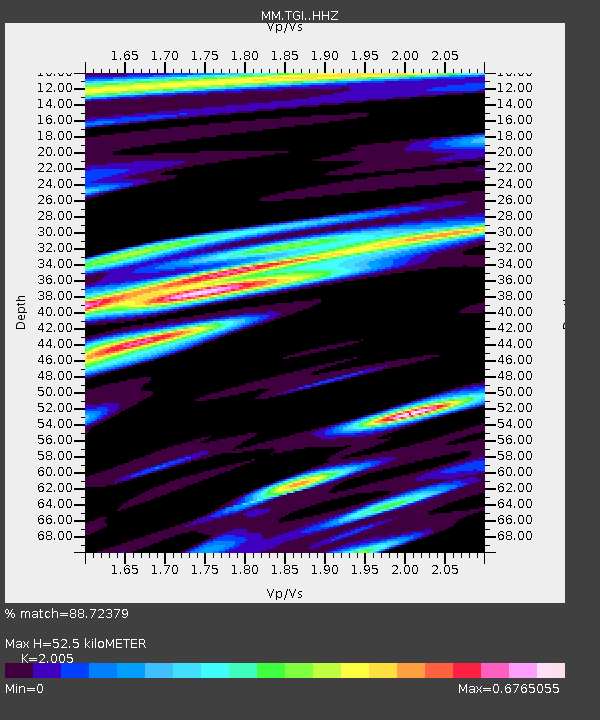
| Estimated Moho Depth: |
52.5 km |
| Estimated Crust Vp/Vs: |
2.01 |
| Assumed Crust Vp: |
6.316 km/s |
| Estimated Crust Vs: |
3.15 km/s |
| Estimated Crust Poisson's Ratio: |
0.33 |
|
| Radial Match: |
88.72379 % |
| Radial Bump: |
400 |
| Transverse Match: |
77.205414 % |
| Transverse Bump: |
400 |
| SOD ConfigId: |
26694651 |
| Insert Time: |
2022-02-05 05:34:38.835 +0000 |
| GWidth: |
2.5 |
| Max Bumps: |
400 |
| Tol: |
0.001 |
|

Signal To Noise
| Channel | StoN | STA | LTA |
| MM:TGI: :HHZ:20220122T05:28:27.830017Z | 22.314447 | 2.0221266E-6 | 9.0619615E-8 |
| MM:TGI: :HHN:20220122T05:28:27.830017Z | 5.127915 | 5.8887053E-7 | 1.1483626E-7 |
| MM:TGI: :HHE:20220122T05:28:27.830017Z | 7.034307 | 6.9557035E-7 | 9.888257E-8 |
| Arrivals |
| Ps | 8.6 SECOND |
| PpPs | 24 SECOND |
| PsPs/PpSs | 33 SECOND |


