You are here: Home > Network List > IU - Global Seismograph Network (GSN - IRIS/USGS) Stations List
> Station JOHN Johnston Island, USA > Earthquake Result Viewer
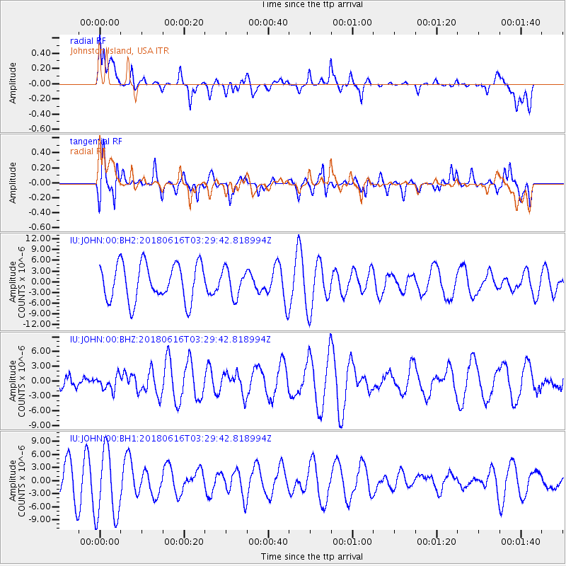
JOHN Johnston Island, USA - Earthquake Result Viewer
*The percent match for this event was below the threshold and hence no stack was calculated.
| Earthquake location: |
Fiji Islands Region |
| Earthquake latitude/longitude: |
-16.2/-177.6 |
| Earthquake time(UTC): |
2018/06/16 (167) 03:23:32 GMT |
| Earthquake Depth: |
10 km |
| Earthquake Magnitude: |
5.5 mb |
| Earthquake Catalog/Contributor: |
NEIC PDE/us |
|
| Network: |
IU Global Seismograph Network (GSN - IRIS/USGS) |
| Station: |
JOHN Johnston Island, USA |
| Lat/Lon: |
16.73 N/169.53 W |
| Elevation: |
2.0 m |
|
| Distance: |
33.7 deg |
| Az: |
14.036 deg |
| Baz: |
194.071 deg |
| Ray Param: |
$rayparam |
*The percent match for this event was below the threshold and hence was not used in the summary stack. |
|
| Radial Match: |
44.123676 % |
| Radial Bump: |
385 |
| Transverse Match: |
46.969734 % |
| Transverse Bump: |
400 |
| SOD ConfigId: |
2709371 |
| Insert Time: |
2018-06-30 03:28:57.470 +0000 |
| GWidth: |
2.5 |
| Max Bumps: |
400 |
| Tol: |
0.001 |
|
Signal To Noise
| Channel | StoN | STA | LTA |
| IU:JOHN:00:BHZ:20180616T03:29:42.818994Z | 0.9026251 | 1.5178234E-6 | 1.6815658E-6 |
| IU:JOHN:00:BH1:20180616T03:29:42.818994Z | 2.4368546 | 7.911023E-6 | 3.2464075E-6 |
| IU:JOHN:00:BH2:20180616T03:29:42.818994Z | 0.7437215 | 3.858957E-6 | 5.1887123E-6 |
| Arrivals |
| Ps | |
| PpPs | |
| PsPs/PpSs | |


