You are here: Home > Network List > N4 - Central and EAstern US Network Stations List
> Station MSTX Muleshoe, TX, USA > Earthquake Result Viewer
MSTX Muleshoe, TX, USA - Earthquake Result Viewer
| Earthquake location: |
Fox Islands, Aleutian Islands |
| Earthquake latitude/longitude: |
53.1/-166.6 |
| Earthquake time(UTC): |
2022/01/22 (022) 05:17:03 GMT |
| Earthquake Depth: |
3.0 km |
| Earthquake Magnitude: |
6.3 Mi |
| Earthquake Catalog/Contributor: |
NEIC PDE/at |
|
| Network: |
N4 Central and EAstern US Network |
| Station: |
MSTX Muleshoe, TX, USA |
| Lat/Lon: |
33.97 N/102.77 W |
| Elevation: |
1167 m |
|
| Distance: |
48.3 deg |
| Az: |
86.712 deg |
| Baz: |
313.57 deg |
| Ray Param: |
0.069455214 |
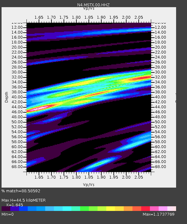
| Estimated Moho Depth: |
44.5 km |
| Estimated Crust Vp/Vs: |
1.64 |
| Assumed Crust Vp: |
6.129 km/s |
| Estimated Crust Vs: |
3.726 km/s |
| Estimated Crust Poisson's Ratio: |
0.21 |
|
| Radial Match: |
88.58592 % |
| Radial Bump: |
270 |
| Transverse Match: |
72.320625 % |
| Transverse Bump: |
400 |
| SOD ConfigId: |
26694651 |
| Insert Time: |
2022-02-05 05:36:16.955 +0000 |
| GWidth: |
2.5 |
| Max Bumps: |
400 |
| Tol: |
0.001 |
|

Signal To Noise
| Channel | StoN | STA | LTA |
| N4:MSTX:00:HHZ:20220122T05:25:14.699005Z | 6.159431 | 1.2978999E-6 | 2.107175E-7 |
| N4:MSTX:00:HH1:20220122T05:25:14.699005Z | 2.7770555 | 6.061457E-7 | 2.1826922E-7 |
| N4:MSTX:00:HH2:20220122T05:25:14.699005Z | 2.3480241 | 5.9666394E-7 | 2.5411322E-7 |
| Arrivals |
| Ps | 5.0 SECOND |
| PpPs | 18 SECOND |
| PsPs/PpSs | 23 SECOND |


