You are here: Home > Network List > NE - New England Seismic Network Stations List
> Station EMMW Machias, ME, USA > Earthquake Result Viewer
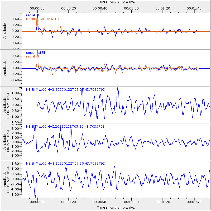
EMMW Machias, ME, USA - Earthquake Result Viewer
*The percent match for this event was below the threshold and hence no stack was calculated.
| Earthquake location: |
Fox Islands, Aleutian Islands |
| Earthquake latitude/longitude: |
53.1/-166.6 |
| Earthquake time(UTC): |
2022/01/22 (022) 05:17:03 GMT |
| Earthquake Depth: |
3.0 km |
| Earthquake Magnitude: |
6.3 Mi |
| Earthquake Catalog/Contributor: |
NEIC PDE/at |
|
| Network: |
NE New England Seismic Network |
| Station: |
EMMW Machias, ME, USA |
| Lat/Lon: |
44.71 N/67.46 W |
| Elevation: |
35 m |
|
| Distance: |
60.6 deg |
| Az: |
53.92 deg |
| Baz: |
316.875 deg |
| Ray Param: |
$rayparam |
*The percent match for this event was below the threshold and hence was not used in the summary stack. |
|
| Radial Match: |
74.28884 % |
| Radial Bump: |
367 |
| Transverse Match: |
63.41748 % |
| Transverse Bump: |
400 |
| SOD ConfigId: |
26694651 |
| Insert Time: |
2022-02-05 05:37:49.942 +0000 |
| GWidth: |
2.5 |
| Max Bumps: |
400 |
| Tol: |
0.001 |
|
Signal To Noise
| Channel | StoN | STA | LTA |
| NE:EMMW:00:HHZ:20220122T05:26:43.703979Z | 4.6207743 | 1.5213219E-6 | 3.292353E-7 |
| NE:EMMW:00:HH1:20220122T05:26:43.703979Z | 2.0282154 | 5.6748746E-7 | 2.7979647E-7 |
| NE:EMMW:00:HH2:20220122T05:26:43.703979Z | 2.183036 | 6.1307935E-7 | 2.8083795E-7 |
| Arrivals |
| Ps | |
| PpPs | |
| PsPs/PpSs | |


